by Heinz-Gerd Röhling, Henning Zellmer, Martin Meschede
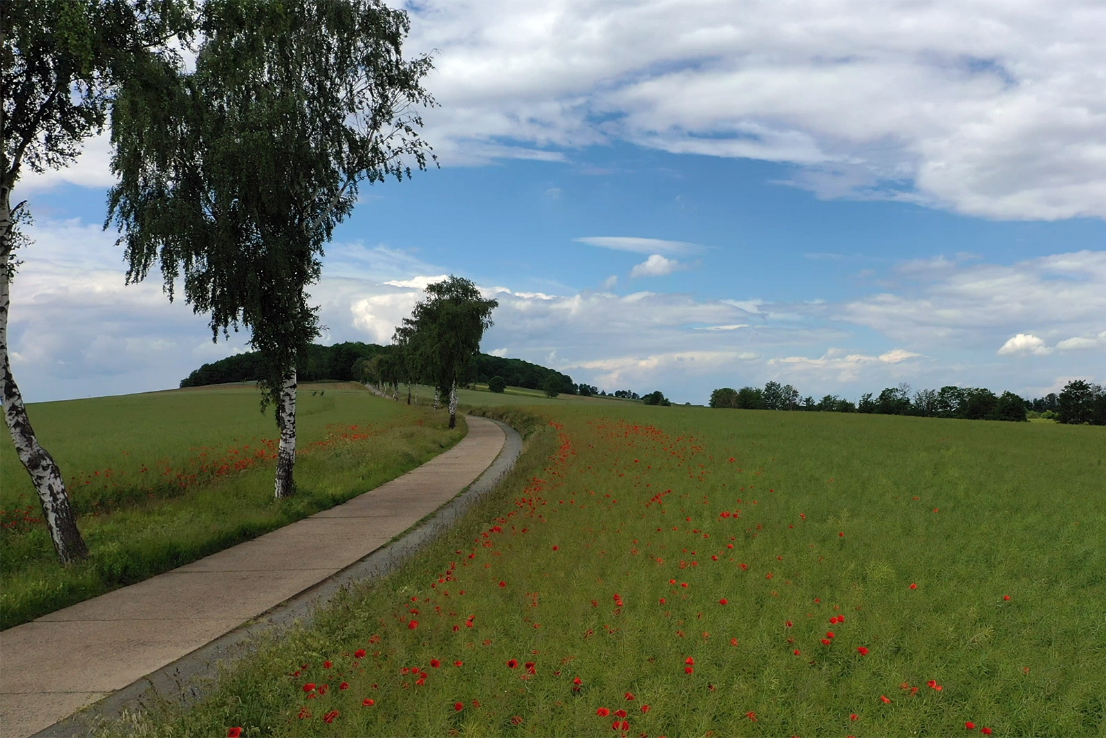
(TK/GK 25 Bl. 3931 Jerxheim, R 44 22844.219, H 57 72766.482 (N 52.083330 E 10.872780 parking lot, N 52.083580 E 10.857300 quarry with stromatolites)
Location: Start of the signposted geopath at the parking lot at the restaurant on the Heeseberg west of Jerxheim, the path with the outcrops is freely accessible.
About 25 km southwest of Braunschweig, the 200 m high Heeseberg rises above the northern Harz foreland. It lies in the southeastern extension of the Asse and belongs geologically to the Asse-Heeseberg structure, a narrow, elongated fold anticline that contains a salt dome in its center (Fig. 1). In the former Asse salt mine, the salts of the Zechstein were mined for many years. Today it is known nationwide for the storage of low-level radioactive waste that has taken place since the 1970s.
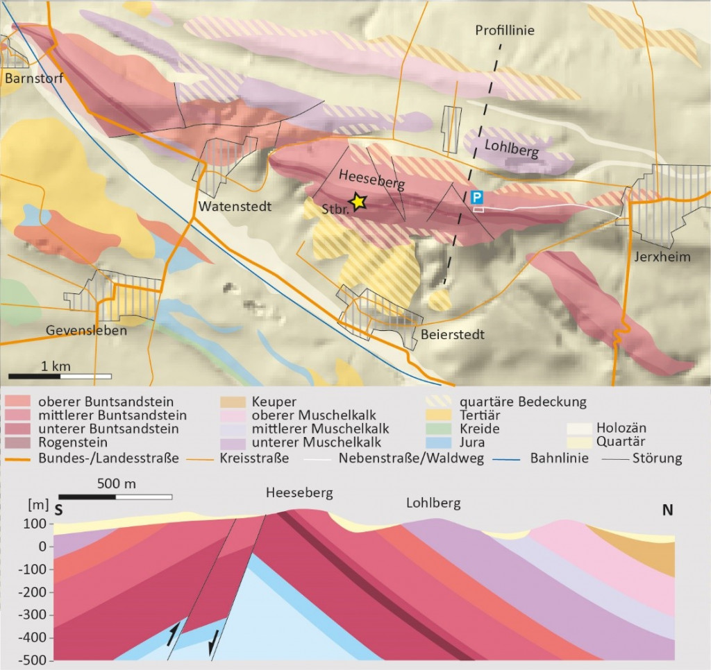
At the Heeseberg, the NE flank of the anticline is exposed, the SW flank is buried under Tertiary and Quaternary deposits. The anticline structure was already formed during the Jurassic and Cretaceous periods around 140 million years ago, when the Zechstein salts deposited in the underground rose in weak zones of the overburden bulging the overlying layers. The deposits of the Buntsandstein, which formed around 250 million years ago, were also uplifted during this process. Today they can be studied in some abandoned quarries on the Hesseberg.
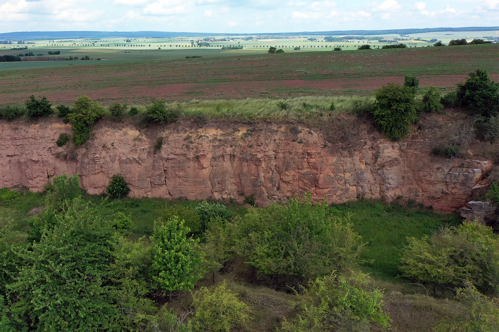
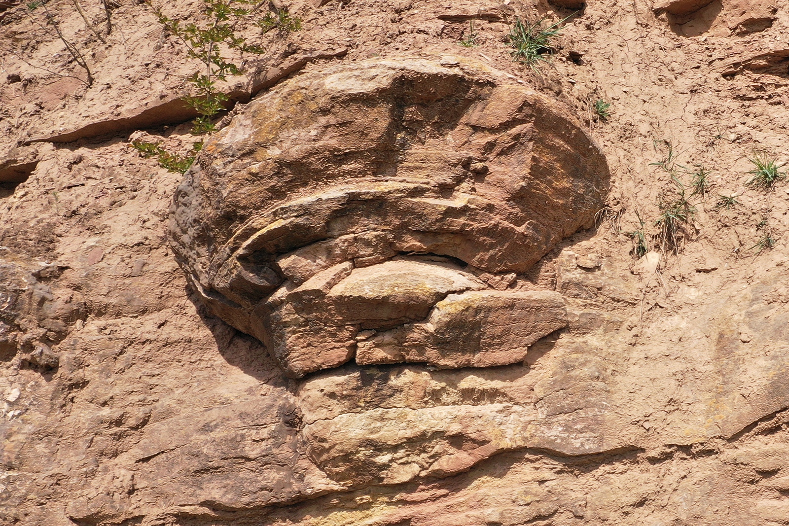
The outcrops on the Heeseberg impressively show the Rogenstein from the upper part of the Bernburg Formation, which belongs to the Lower Buntsandstein (Paul in Hauschke et al. 1998, Voigt et l., 2011, Röhling 2013, Käsbohrer & Kuss 2019) and in which contain many “cauliflower-like” looking stromatolites.
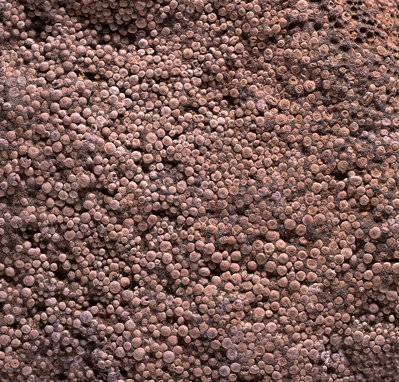
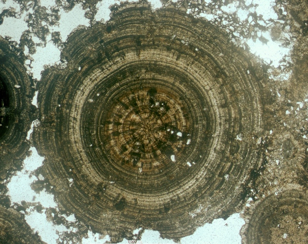
The Rogenstein, which was an important building block in the Braunschweig region for many centuries, is a typical oolite. An oolite consists mostly of so-called ooids, which are usually 1-2 mm large rounded structures that form in moving water as precipitations around crystallization nuclei (Fig. 2). Such ooids with their concentric structure (Fig. 3) are still formed today in the rhythm of the waves in shallow water areas of warm seas, but they are also known from oversalted lakes. Small particles of foreign material, e.g. tiny shell fragments or small grains of sand, serve as crystallization nuclei for the ooids. In warm water, oversaturation of carbonates easily occurs, so that as evaporation progresses, aragonite (CaCO3) or magnesium calcite precipitates (Kalkowsky 1908). In the Rogenstein, the individual ooids can reach diameters of up to 10 millimeters. They are among the largest known ooids (e.g. Paul 1999).
Of particular importance on the Heeseberg are the numerous stromatolites occurring in its quarries. The term “stromatolite” was first used by Kalkowsky (1908) on the basis of findings from the wider area around the Asse, which also includes the Heeseberg. Therefore, this ridge is to be regarded as the type locality of stromatolites which is of great scientific importance internationally (see also Hauschke et al 2012). The quarries on the Heeseberg, which were originally set up to mine the coveted Rogenstein, were awarded National Geotope status in 2007 (Roeber et al. 2006a, b).
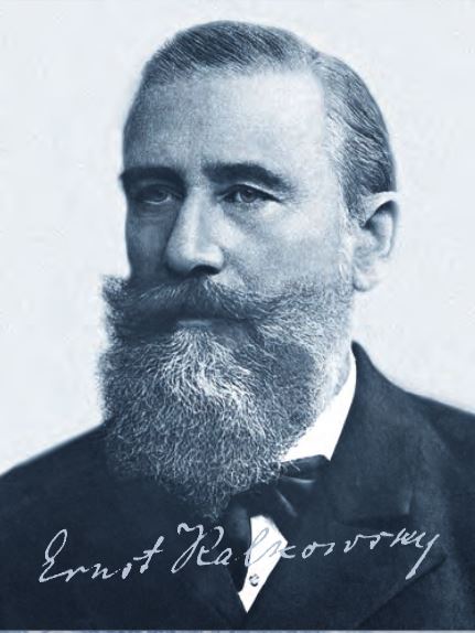
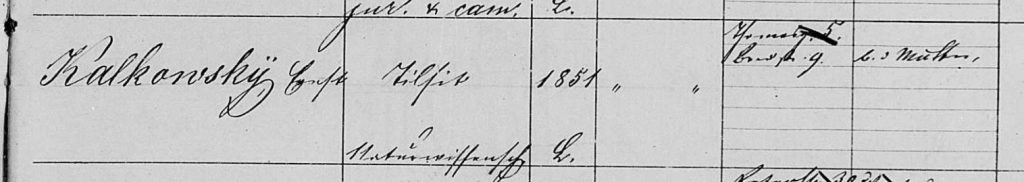
Ernst Kalkowsky, born in Tilsit in 1851, studied mineralogy and geology at the University of Leipzig. From 1894-1920 he held the chair of mineralogy and geology at the University of Dresden and was director of the Grand Ducal Mineralogical Collections. He is best known for his investigations of nephrites, oolites and stromatolites.
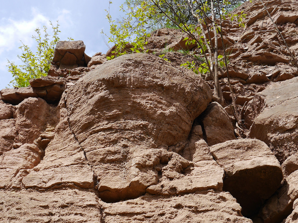
A shallow lake or, according to more recent studies, a shallow marginal bay of a sea is usually assumed to be the formation area for the sequence of layers with oolites and stromatolites, such as those found on the Heeseberg (terminal lake or playa lake; e.g. Paul 1982, 1993, 1999, Paul & Peryt 2000, Röhling 2013, Heunisch & Röhling 2016; marine influence according to Usdowski (1963) Weidlich (2007) Stromatolites are columnar or nodular formations in the rock that often look like cauliflowers and are finely parallel laminated inside (Fig. 4, 5) They have been known since the Precambrian, in whose deposits they occur particularly frequently, the oldest being around 3.5 billion years old (Gehler et al. 2008, Hochsprung et al. 2011).
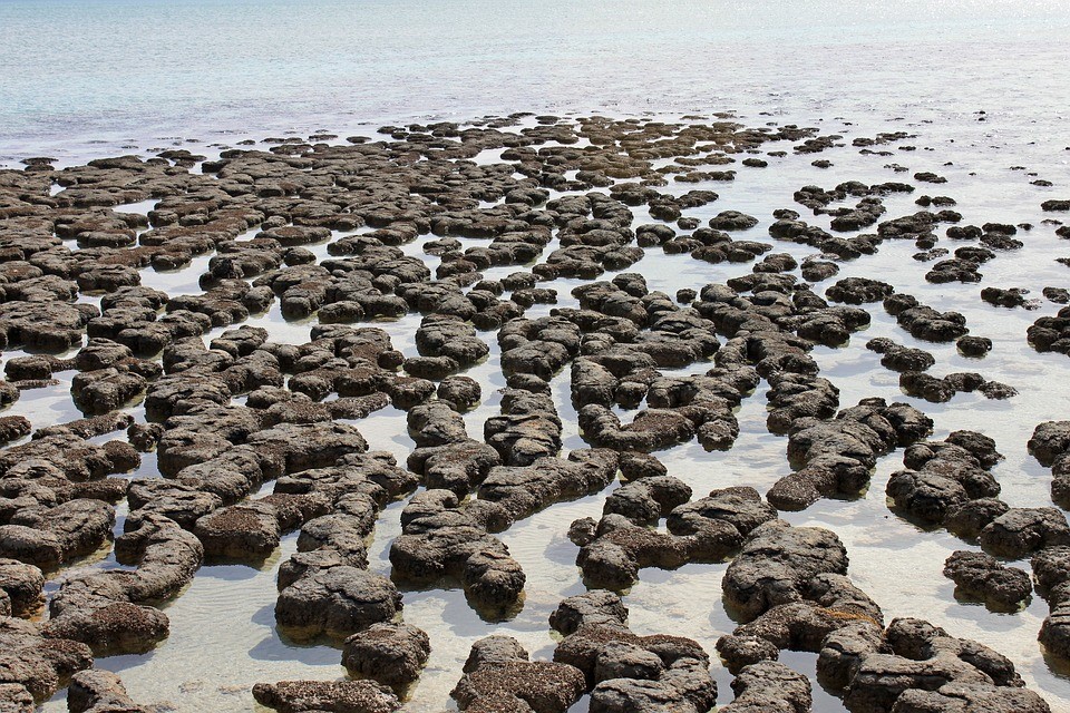
Since stromatolites still grow in some marine areas, lagoons and lakes (e.g. Hamelin Pool in Western Australia, Fig. 6), it is fairly well understood how they are formed. Some cyanobacteria and other microorganisms produce lime, while others secrete a slimy coating. Under favorable conditions, such microorganisms can form so-called microbial mats. After a while, the precipitated lime, along with fine particles captured by the mucus, bury the microbial mat and the process begins again. In this way, numerous thin limestone crusts are deposited rhythmically on top of each other and a stromatolite grows (Fig. 5; e.g. Paul & Peryt 2000, Gehler et al. 2008). The fact that stromatolites became rarer with the onset of the Cambrian is probably due to microbial mats being grazed by the invertebrates that then appeared. Today, stromatolites are therefore only found in waters where hardly any other organisms can live, such as in some bays on the coast of Australia, where the water is very warm and salty.
The outcrops on the Heeseberg belong to the Heeseberg Nature Reserve and are part of the UNESCO Global Geoparks Harz.Braunschweiger Land.Ostfalen (HBLO), which cares for the Heeseberg geopath here. In the nature reserve, in addition to the outcrops with the stromatolites, the dry grassland should be mentioned, which is one of the most north-western foothills of the Central German dry area. Species communities that are unique in Lower Saxony have been preserved or developed here.
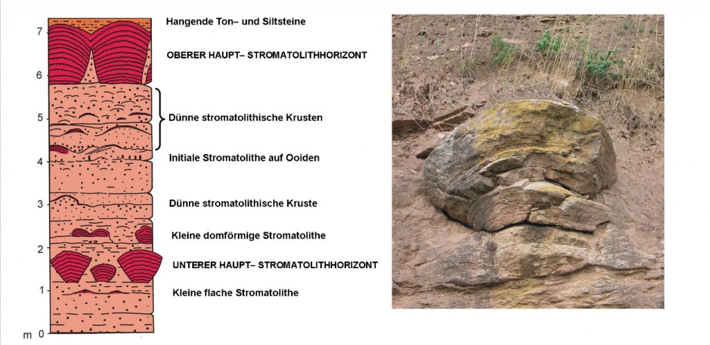
The Hesseberg quarries are part of a geopath that starts at the parking lot of the Heeseberg restaurant and is about 3.5 km long. The westernmost quarry (yellow star in Fig. 1) shows in a particularly impressive way two horizons with stromatolites (Fig. 4) embedded in the Rogenstein of the Lower Buntsandstein. In the upper part of this quarry, mainly reddish-brown, rarely also grey-green mudstones with fine sandstone layers can be observed.
For those particularly interested:
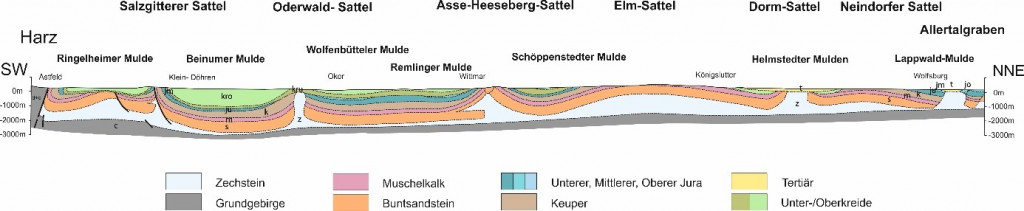
The ridge of the Heeseberg is formed by the so-called Rogenstein zone of the Lower Buntsandstein and sandstones of the Middle Buntsandstein. On a clear day, there is a wonderful panoramic view to the south over the Remlingen Syncline and large parts of the northern Harz foothills (Fig. 7, 8). At the foot of the slope in the foreground is the village of Beierstedt, to the left Jerxheim. The depression in the middle ground, which runs across the line of sight, is formed by the depression of the Großer Bruch. Behind it, several ridges rise in the background, which are also due to rising salt in the underground. They were all initiated in the Mesozoic. From west to east these are Harly and Salzgitterer Höhenzug, Kleiner and Großer Fallstein and Huy. The Harz Mountains rise further south in the background. To the north, the Lohlberg can be seen in the foreground, where lower Muschelkalk has been exposed in an abandoned quarry. Behind it stretches the wavy surface of the Schöppenstedt Syncline, which, like the Remlingen Syncline Mulde, is covered by Upper Cretaceous limestone. The nearest village is Ingeleben. Further north, beyond the Schöppenstedt Syncline, rises the wide anticlinal structure of Muschelkalk of the Elm, at the eastern end of which the Tertiary deposits of Schöningen with their lignite (former Buschhaus power plant) occur.
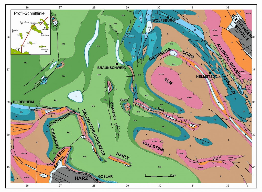
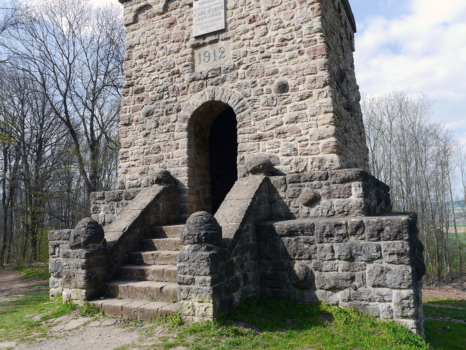
The construction material of the observation tower on the Heeseberg, built in 1912, consists mainly of Rogenstein and stromatolites of the Lower Buntsandstein from the Heeseberg and of cut stones of the Lower Muschelkalk from the neighboring Lohlberg (see Fig. 1). On weathered surfaces of the Rogenstein, the ooids are easily recognizable as small, pea-shaped limestone globules. The more than head-sized stone balls on both sides of the entrance staircase are stromatolites worked by the stonemason. A little further west in the forest, for an unknown reason, a larger stromatolite was attached to a pillar by the wayside.
The calcareous layers in the lower part of the quarry marked as “experience area 2” are about 4 m thick oolite banks with ooids no larger than 5 mm (Figs. 2, 3). The individual banks show ripple marks in places and reveal irregularly structured microbial mats. The upper part of the exposed limestone sequence, on the other hand, is dominated by stromatolites about 1 m thick. They are clear indicators that there was once a shallow water zone in a warm, probably over-salted waterbody.
In another quarry area along the geopath, the upper part of the Buntsandstein section on the Heeseberg is accessible, which is mainly made up of reddish-brown to grey-green fine sandstone rich in clay, silt and feldspar with a few inclusions of fine-grained oolites. On closer inspection, these rocks reveal sedimentary structures such as parallel, oblique and flaser layers as well as current and wave ripples and occasionally dry cracks. Measurements of the direction of flow show that the deposited sediments were transported from the south-east to the north-west.
The third and westernmost quarry along the geopath shows in a particularly impressive way two horizons with stromatolites embedded in the Rogenstein of the Lower Buntsandstein (Fig. 3, 4). In the upper part of this quarry, mainly reddish-brown, rarely also grey-green mudstones with fine sandstone layers can be observed.
The sediments and sediment structures of the quarries on the Heeseberg suggest that around 250 million years ago there was a flat area of an inland sea or salt lake (such as the actual Aral Sea; Röhling & Lepper 2013, Lepper et al. 2013, Käsbohrer & Kuss 2019). Under a warm, dry climate (Paul & Puff 2013), the relatively fine sediments delivered by tributaries were deposited at shallow water depths; occasionally it even dried up. The oolites and stromatolites formed at periods when the sediment supply decreased and increased evaporation led to oversalting in the depositional basins (e.g. Paul 1999, 2008). In contrast, Usdowski (1963) and Weidlich (2007) assume shallow marine conditions (see also Heunisch & Röhling 2016). The growth of the stromatolites was additionally supported or made possible at all by the fact that the microbial mats were hardly grazed under these conditions and shortly after the great extinction event at the turn of the Permian/Triassic (see also Hiete et al. 2005, 2013).
A special aspect of the geopath on the Heeseberg is the sheep pasture to preserve the landscape with a semi-arid grassland (FEMO – Freilicht- und Erlebnismuseum e.V. 2008). For centuries, animals grazed here to prevent the forest from encroaching again, and the preservation of the semi-arid grassland is only possible through the traditional use as sheep pasture. The sheep on the Heeseberg keep the turf short and the landscape open. Their hooves create open spaces in the rocky ground that insects can use as habitats. Along the footpaths, the migrating herds spread the plant seeds clinging to their fur and claws. Prickly, bitter or strongly aromatic-tasting plants are spurned by the sheep. Adonis and cypress spurge are spared, while thistles, restharrow and field eryngo form larger stocks. Only wild roses, sloes and hawthorns spread as bushes on the slopes. The landscape management model practiced on the Heeseberg is only possible through coordinated cooperation between farmers, authorities and various other interest groups. It has proven to be a very successful method of protecting valuable sections of our cultivated landscape and has model character.
3D models

A high-resolution, scientifically usable 3D model will follow soon on V3Geo.
Impressions


References
FEMO – Freilicht- und Erlebnismuseum e.V. (Hrsg.) (2008): Von der Salzwiese zum Steppenrasen. Erlebnispfad Heeseberg – Großes Bruch – Hünenburg. – 51 S.; Königslutter (FEMO – Freilicht- und Erlebnismuseum e.V.).
Gehler, A., Reich, M. & Reitner, J. (2008): Stromatolithe. Begleitheft zur Sonderausstellung im Geowissenschaftlichen Museum Göttingen. – 47 S.; Göttingen (Geowissenschaftliches Museum Göttingen).
Hauschke, N., Lange, J.-M., Erler, D., Mertmann, D. & Röhling, H.-G. (2012): Ernst Kalkowsky (1851–1938) – Porträt eines bedeutenden Geowissenschaftlers und des Erforschers von „Oolith und Stromatolith im norddeutschen Buntsandstein“. – Geohistor. Blätter, 22: 1–27; Berlin.
Hauschke, N., Szurlies, M. & Wilde, V. (1998): Excursion I: Stratigraphy, sedimentary environments, palaeoecology and cyclicity of Buntsandstein, Muschelkalk and Keuper in the central Germanic Basin (North of the Harz Mountains). – Hallesches Jahrb. Geowiss. Reihe B, Beih., 6: 228–239, Halle (Saale).
Heunisch, C. & Röhling, H.-G. (2016): Early Triassic phytoplankton episodes in the Lower and Middle Buntsandstein of the Central European Basin. – Z. Dt. Ges. Geowiss. (German J. Geol.), 167 (2-3): 227–248; Stuttgart.
Hiete, M., Berner, U., Heunisch, C. & Röhling, H.-G. (2005): A high-resolution inorganic geochemical profile across the Zechstein-Buntsandstein boundary in the North German Basin. – Z. Dt. Ges. Geowiss., 157: 77–106; Stuttgart.
Hiete, M. Röhling, H.-G., Heunisch, C. & Berner, U. (2013): Facies and climate changes across the Permian-Triassic boundary in the North German Basin: insights from a high-resolution organic carbon isotope record. – Geol. Soc. London, Spec. Publ., 376: 549–574; London.
Hochsprung, U., Joger, U., Kosma, R., Krüger, F.J., Schindler, E., Wilde, V. & Zellmer, H. (2011): Es begann am Heeseberg… Stromatolithe und der Ursprung des Lebens. – 60 S.; München (Verlag Dr. Friedrich Pfeil).
Käsbohrer, F. & Kuss, J. (2019): Sedimentpetrographische Untersuchungen der Calvörde-Formation (Unterer Buntsandstein, Untertrias). – Hall. Jb. Geowiss., 42: 1–24; Halle.
Kalkowsky, E. (1908): Oolith und Stromatolith im norddeutschen Buntsandstein. – Z. dt. geol. Ges., 60: 68–125; Berlin.
Paul, J. (1982): Der Untere Buntsandstein des Germanischen Beckens. – Geol. Rundschau, 71: 795–811; Berlin.
Paul, J. (1993): Anatomie und Entwicklung eines permo-triassischen Hochgebietes: die Eichsfeld-Altmark-Schwelle. – Geol. Jb., A 131: 197–218; Hannover.
Paul, J. (1999): Oolithe und Stromatolithe im Unteren Buntsandstein. – In: Hauschke, N. & Wilde, V. (Hrsg.): Trias – Eine ganz andere Welt: 263–270; München (Verlag Dr. Friedrich Pfeil).
Paul. J. (2008): Kalkowsky’s stromatolites and oolites at the Heeseberg quarries. – In: Reitner, J., Quéric, N.-V. & Reich, M. (Hrsg.): Geobiology of stromatolites. International Kalkowsky Symposium Göttingen, October 4-11, 2008. Abstract Volume and Field Guide to Excursions, 145–152; Göttingen (Universitätsverlag Göttingen).
Paul, J. & Puff, P. (2013): Lithostratigraphie des Buntsandsein in Deutschland. – In: Deutsche Stratigraphische Kommission (Eds.; Koordination und Redaktion: J. Lepper & H.-G. Röhling für die Subkommission Perm-Trias): Stratigraphie von Deutschland XI. Buntsandstein. – Schriftenr. dt. Ges. Geowiss., 69: 69–149; Hannover.
Paul, J. & Peryt, T.M. (2000): Kalkowsky’s stromatolites revisited (Lower Triassic Buntsandstein, Harz Mountains, Germany). – Palaeogeogr., Palaeoclimat., Palaeoecol., 161: 435–458.
Röber, St., Zellmer, H. & Röhling, H.-G. (2006a): Fossile Algenrasen im nördlichen Harzvorland. „Stromatolithen am Heeseberg bei Jerxheim. – In: Look, E.-R. & Feldmann, L. (Hrsg.): Faszination Geologie. Die bedeutendsten Geotope Deutschlands, 12–13; Stuttgart, E. Schweizerbart’sche Verlagsbuchhandlung (Nägele & Obermiller).
Röber, S., Röhling, H.-G. & Zellmer, H. (2006b): Die Stromatolithen am Geologie-Natur-Erlebnispfad „Heeseberg“. – In: Weber, J. & Bühn, S. (Hrsg.): Geotope und Geoparks – Schlüssel zu nachhaltigem Tourismus und Umweltbildung. 9. Internationale Jahrestagung der Fachsektion GeoTop der Deutschen Gesellschaft für Geowissenschaften, 24.-28. Mai 2005 in Lorsch im Geopark Bergstraße-Odenwald. – Schriftenr. dt. Ges. Geowiss, 42: 51–55; Hannover.
Röhling, H.-G. (2013): Der Buntsandstein im Norddeutschen Becken – regionale Besonderheiten. – In: Deutsche Stratigraphische Kommission (Eds.; Koordination und Redaktion: J. Lepper & H.-G. Röhling für die Subkommission Perm-Trias): Stratigraphie von Deutschland XI. Buntsandstein. – Schriftenr. dt. Ges. Geowiss., 69: 269–384; Hannover.
Usdowski, H.-E. (1963): Der Rogenstein des norddeutschen Unteren Buntsandsteins, ein Kalkoolith des marinen Faziesbereichs. – Fortschr. Geol. Rheinland u. Westfalen, 10: 337–342; Krefeld.
Voigt, T., Gaupp, R. & Röhling, H.-G. (2011): Lake deposits of the Early Triassic Buntsandstein in Central Germany: Type localities of oolites and stromatolites. – 5th Int. Limnological Congress, at Konstanz, Abstract Volume and Field Guide: 191–211; Konstanz.
Weidlich, O. (2007): PTB mass extinction and earliest Triassic recovery overlooked? New evidence for a marine origin of Lower Triassic mixed carbonate-siliciclastic sediments (Rogenstein Member), Germany. – Palaeogeogr., Palaeoclimatol., Palaeoecol., 252: 259–269; Amsterdam.
Zellmer, H., Röhling, H.-G. & Wilde, V. (2018): Kurze Einführung in die Geologie des Braunschweiger Landes. – Mitt. oberrhein. geol. Ver., N.F. 100: 9–51; Stuttgart.