TL;DR (too long; didn’t read)
The Vulkaneifel region is unique in the world for the density of the volcano type “Maar”. In the Vulkaneifel there are also cinder cone volcanoes. 350 volcanoes form a unique landscape. Many maar volcanoes are dry and filled with sediments, but 12 contain a maar lake. These lakes are called the “eyes of the Eifel”. They include the three Daun maars: the Schalkenmehrener, the Weinfelder and the Gemündener maar. They erupted in the time about 20,000 – 30,000 years ago. The volcanic landscape is designated as a nature park and UNESCO Global Geopark and is a popular destination for tourists.
Travelling through the land of maars and volcanoes: from the state spa Bad Bertrich on the Moselle to the Goldberg near Ormont on the Belgian border, a landscape stretches across the western Eifel that is unparalleled anywhere else in Europe, let alone the world. The highest density worldwide and at the same time type locality for the volcano type “Maar” – these are the worldwide unique selling points of the volcanic Eifel.
Volcanic cones, mineral water springs, a unique density of natural phenomena and especially the maars are the attractions of this landscape in the heart of Europe. With the Daun Maars and the volcanic system Mosenberg-Meerfelder Maar, the Vulkaneifel offers two geo-locations, which were awarded as “Germany’s most important geotopes”.
Scientifically, the region is called the West Eifel Volcanic Field (WEVF). For more than 200 years, the West Eifel Volcanic Field with the Maar volcanism has been scientifically researched by numerous international researchers.
The “Eyes of the Eifel”
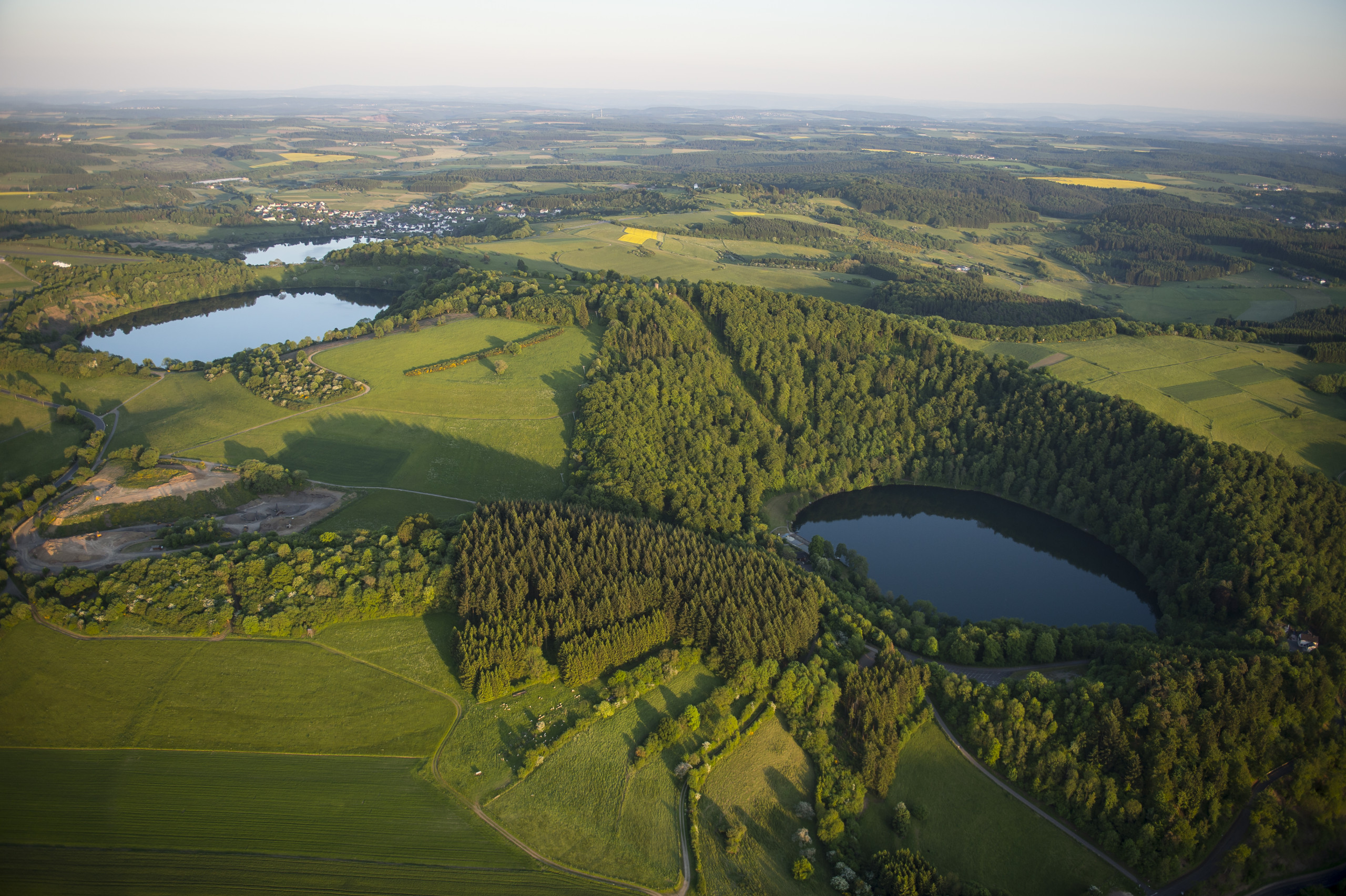
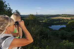
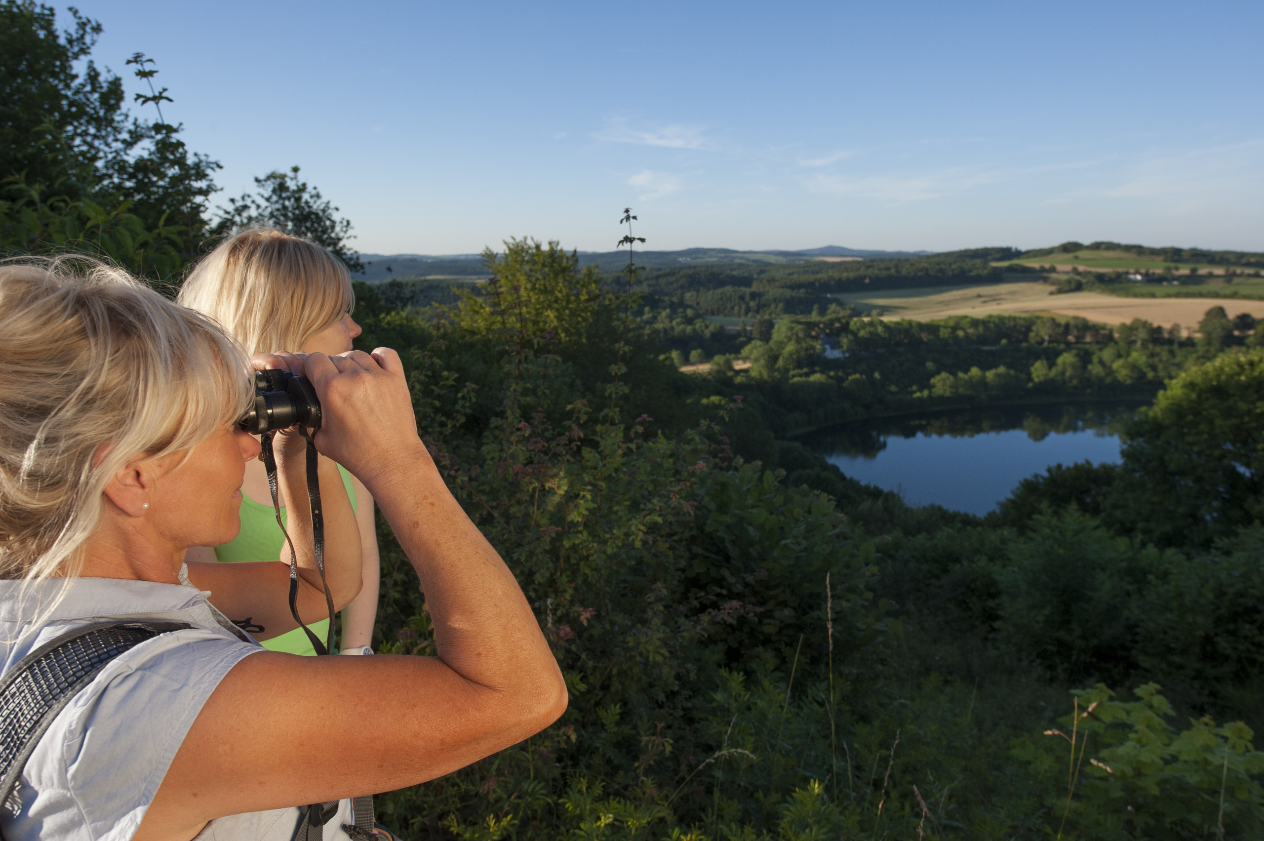
The Maars – circular lakes with water in deep to azure blue, framed by the green of wooded slopes – are also called the “eyes” of the region. They have always been symbols of the Eifel, adorn numerous postcards and, as natural monuments, are worth a trip to many people. From a bird’s eye view, the former craters are clearly visible. In addition to a mountain crater lake and the eleven water-filled maars, many more become recognizable: some are currently silting up and are home to raised bogs, others are already completely dry and are only recognizable as a circular depression. 78 maars are identified in the Vulkaneifel so far.
The Eifel volcanoes were active for the first time 45 to 35 million years ago. From this time (Middle Miocene; e.g. Neuffer, Gruber & Lutz, 1994) originates among others the Eckfeld Maar. A second phase began about one million years ago. The last eruption, the Ulmen Maar, occurred 10,900 years ago. This makes the Ulmen Maar the youngest volcano in Central Europe and one of the 100 most important geo-heritage sites worldwide. About three quarters of the volcanoes originate from the younger second phase.
With the expansion of the Geopark in 2021, two Albian volcanoes (Lower Cretaceous) complete the volcanic history of the Vulkaneifel from the Quaternary through the Paleogene & Neogene to the Cretaceous.
In fact, the geology of the Vulkaneifel is even more diverse than just volcanic origin. Red sandstones and abundant marine sediments tell of peaceful and turbulent times over the last 400 million years. Few places on earth offer such a clear and fascinating insight into their development and further change.
Formation of the Maars
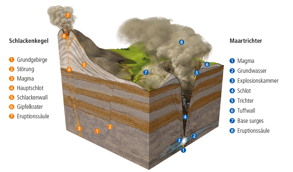
Maars do not only exist in the Eifel, they are a worldwide phenomenon. The reasons for their formation and their special appearance are based on geological conditions. First of all, molten rock rising from the earth’s interior is responsible for volcanic activity: magma.
Thanks to maar research and the observation and study of current maar eruptions, we now know quite precisely how the maars in the Vulkaneifel were formed and what dramatic effects their formation must have had on the landscape. Molten magma meets water-bearing strata during its ascent. This water evaporates abruptly, massive explosions are the result. The surrounding rock at the point of contact is fractured, transported upward and ejected. The ejected explosion chamber then collapses and a funnel remains on the earth’s surface, surrounded by a ring-shaped wall with the ejected materials – a maar has been created.
The collapsed funnel can fill with water and become the Maar Lake. In the course of millennia and millions of years, the maar will change its appearance. Thus, maars silt up over time and turn into bogs. But their traces in the landscape will remain, like here in the Vulkaneifel.
Landscape of the Daun Maars
Three water-filled maars as well as numerous dry maars are called “Dauner Maarlandschaft”. The Schalkenmehrener Maar, the Weinfelder Maar and the Gemündener Maar are lined up on a conveyor fault running from SE to NW and erupted in the following order:
- Schalkenmehren dry maar
- southern Schalkenmehren Marsh Maar
- southern Schalkenmehren twin maar
- Gemünden Maar
- Weinfeld Maar
The time of formation of the maar landscape is estimated to be about 20,000 – 30,000 years before today (Würm ice age). Two other dry maars and the Hoher List cinder cone are even older. The fault transects the following Lower Devonian rock strata from SE to NW: First the Herdorf strata, then the Eckfeld strata and third the Reudelsterz strata, i.e. the transition from the Siegen stage to the Lower Ems stage (Devonian) is located here. The older maars and the cinder cone Hoher List lie in the Herdorf strata. In many cases Maartephra covers the Lower Devonian in this area.
Scientific tradition of the Vulkaneifel
The international importance of Westeifel volcanic field is largely based on the scientific research of maar volcanoes, which has been conducted by numerous international researchers for more than 200 years. The Vulkaneifel is the typical place of maar volcanism, as the model of formation of maars by phreatomagmatic eruptions was established here (Lorenz, 1986). The word “maar” is also a local term from the Vulkaneifel.
The bowl-shaped structures of volcanic origin were first described in 1819 by Steininger, a local school teacher (Steininger, 1820). August Thienemann established the trophic system of freshwater lakes based on the Maar lakes in 1915.
In the 19th and 20th centuries, research was conducted by many well-known geologists, chemists, mineralogists, geographers, and others (e.g., von Dechen, Cipa and Rahm, Frechen, Straka, Zimanowsky, Mertes), which contributed significantly to establishing and strengthening the scientific basis for (maar) volcanism worldwide.
The volcanic landscape itself was explored by geophysical campaigns carried out by Büchel since the 1980s (e.g. Büchel, 1984). Detailed investigations of the magma-gas system were extensively carried out by Schmincke, leading to the standard book publication on Eifel volcanoes (Schmincke, 2009).
In particular, Negendank, Brauer, and Zolitschka developed research on annually laminated sediments from some of the water-filled maars, so-called warves (e.g., Negendank & Zolitschka, 2007, Zolitschka et al., 2000). The warves provide an important insight into the lake sediments and can be used to interpret the climate during the lake history of the maar in terms of local weather. Therefore, the sediments are used as a climate archive, with the lake sediments of Meerfelder Maar as well as Holzmaar being the most prominent in the scientific community (e.g., Brauer et al., 2008).
The Eifel Mountains are still rising by about one millimeter a year. Geophysicists have found that the earth’s crust beneath the Eifel is much thinner than in most other parts of the world. There has been much discussion of the assumption of a plume, i.e., a magma-forming zone near the Earth’s crust, made by Ritter et al. (Eifelplume; 1997-2005, see e.g. Ritter et al., 2001 or Ritter, 2007). And all indications are that volcanoes could still form here. The Eifel is one of the best-studied volcanic regions on Earth and is under constant observation.
Currently, a seismic measurement project has been running since 2022 by the GeoForschungsZentrum Potsdam (Large-N project; gfz-potsdam.de, 2022).
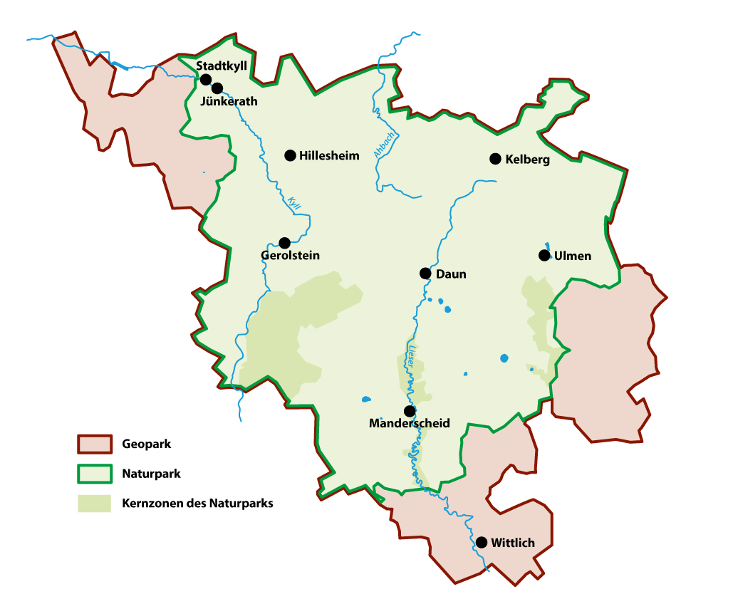
Naturepark and UNESCO Global Geopark Vulkaneifel
Geo & Bio – they belong together: this is also the case in the Vulkaneifel – the region is recognized as a UNESCO Global Geopark and awarded as a nature park. UNESCO Global Geoparks are areas with geological sites and landscapes of international geoscientific importance. They build a bridge of the earth’s historical past, the formation of the landscape and the cultures and traditions of the people created by land use. The Vulkaneifel is one of four founding regions of the “Global Geoparks” network in 2004 and has been living the bottom-up approach since the first initiatives in the 1980s. Since 2015, there is the recognition as UNESCO Global Geoparks – from the beginning, the Vulkaneifel was part of it.
As the eighth nature park in Rhineland-Palatinate, the Vulkaneifel Nature Park was officially inaugurated in a ceremony on May 31, 2010. The new nature park has a unique natural quality in the combination of maars, volcanoes and varied cultural landscapes. These are excellent conditions for sustainable development in combination with nature-friendly land use, regional value creation, nature-based tourism and economic development.
Geoparks are a mirror into the past and create perspectives for a sustainable future. The region has set itself the task of linking earth or geosciences and tourism with each other and thus sending out impulses into the most diverse areas, be it gastronomy, art, culture, sports or leisure. With a stronger focus on the geological heritage of the landscape, without losing sight of the integrity of the living nature, the Vulkaneifel Nature and Geopark wants to contribute to the sustainable development of the region together with the political and touristic actors of the region.
Further info at: www.geopark-vulkaneifel.de
3D-Model
Impressions
Literature
Büchel, G. (1993): Maars of the Westeifel, Germany. – In: Negendank, J. F. W. & Zolitschka, B. (Hrsg.): Paleolimnology of European maar lakes. – Lecture Notes Earth Sci., 49: 1–13; Berlin – Heidelberg – New York (Springer).
Büchel, G., Lorenz, V. & Weiler, H. (1984): Das Westeifel-Vulkanfeld: Maare, Schlackenkegel und Hydrogeologie (Exkursion H am 26. und 27. April 1984). – Jahresber. Mitt. oberrhein. geol. Ver., N.F. 66: 107–128; Stuttgart.
Lange, T., Cieslack, M., Lorenz, V. & Büchel, G. (2022): Zeitliche Abfolge der vulkanischen Ereignisse im SE-Teil des Vulkanfeldes der Westeifel während des Weichsel-Glazials. – Jber. Mitt. oberrhein. geol. Ver., N.F. 104: 313-365; Stuttgart (Schweizerbart).
Lange, T., Lorenz, V., Köppen, K.-H., Büchel, G. (2019): Neue Aspekte zum Vulkanismus der Westeifel. – Jber. Mitt. oberrhein. geol. Ver., N.F. 101: 227-250; Stuttgart (Schweizerbart).
Lorenz, V. (1986): On the growth of maars and diatremes and its relevance to the formation of tuff-rings. – Bull. Volcanol., 48: 265-274; Berlin – Heidelberg (Springer).
Lutz, H., & Lorenz, V. (2013): Early volcanological research in the Vulkaneifel, Germany, the classic region of maar–diatreme volcanoes: the years 1774–1865. Bulletin of volcanology, 75, 1-16.
Schmincke, H. U. (2009): Vulkane der Eifel: Aufbau, Entstehung und heutige Bedeutung. Springer Spektrum.
Steininger, J. (1820): Die erloschenen Vulkane in der Eifel und am Niederrheine. Ein Bericht an die Gesellschaft nützlicher Forschungen zu Trier. – 2; 82; Kupferberg, Mainz.