TL;DR (too long; didn’t read)
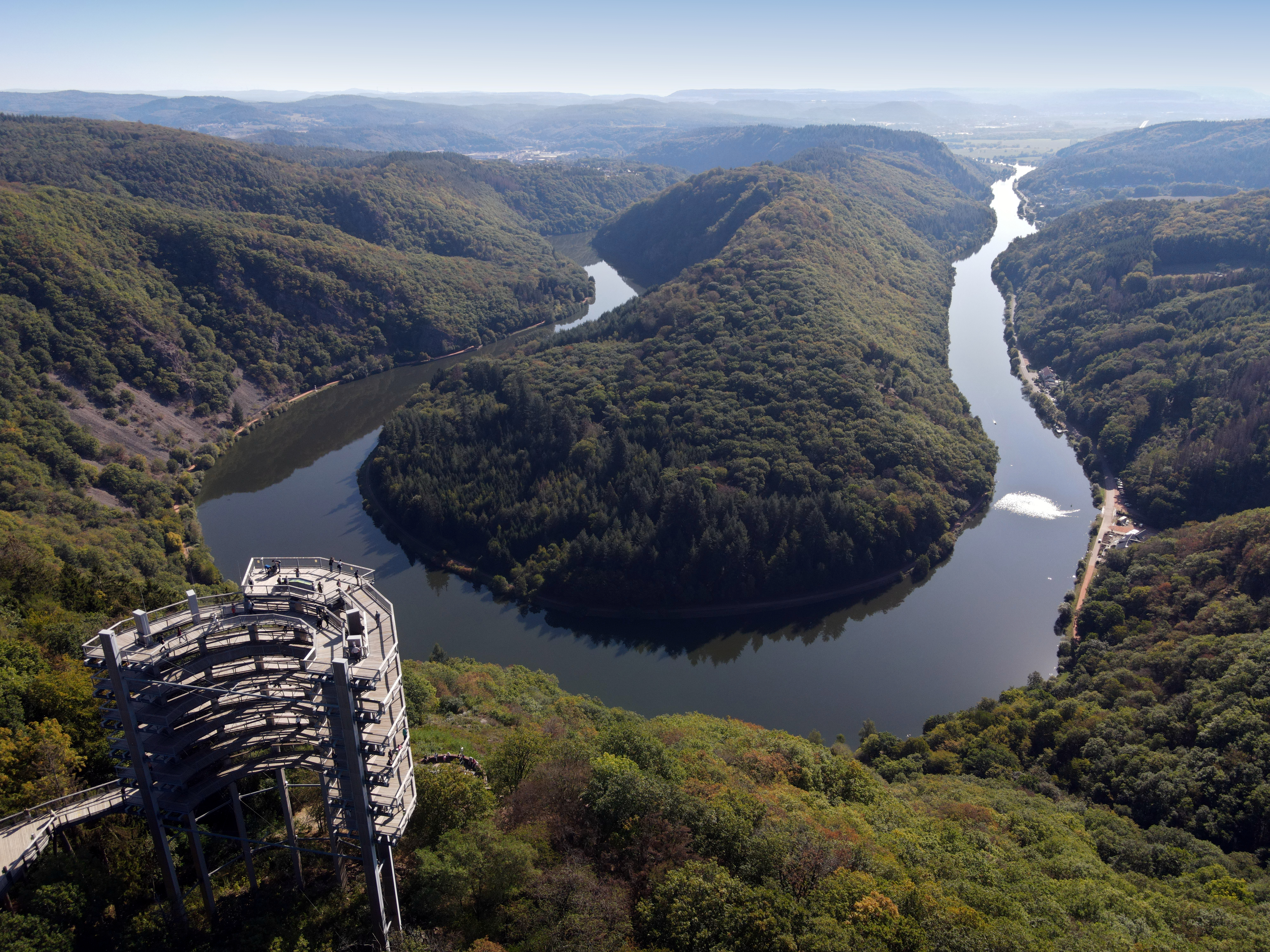
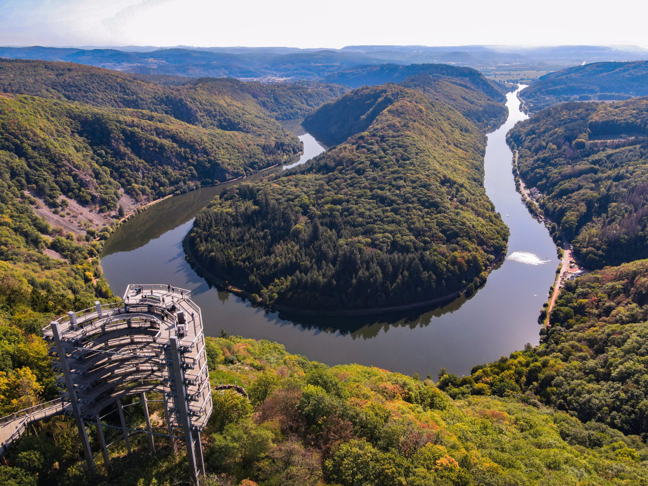
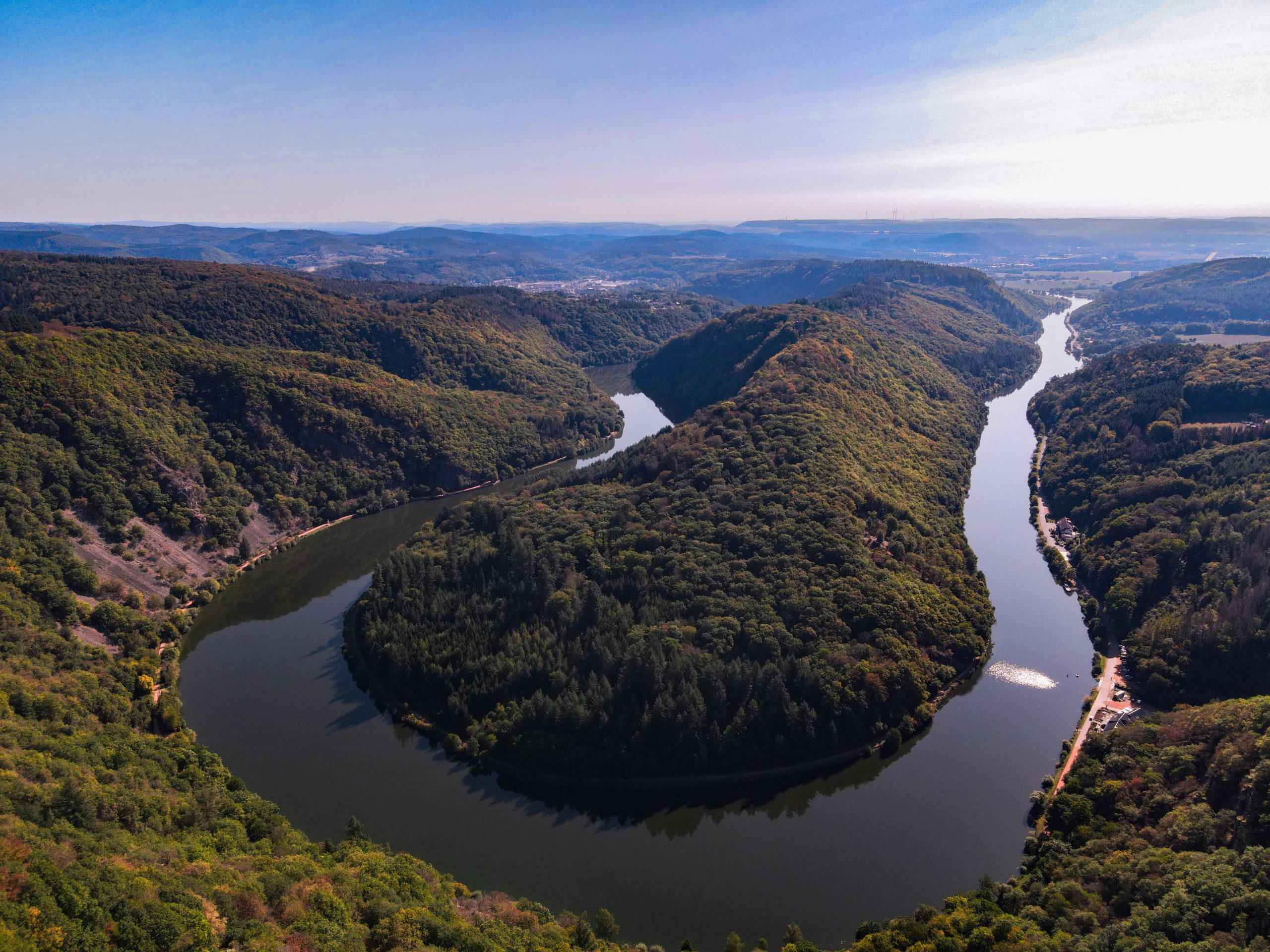
The Saarschleife near Mettlach represents a large river bend. The beautiful landscape can be best seen from the viewpoint “Cloef”. The river Saar formed about 23 million years ago when the meandering river bed started to cut into the bedrock until it reached the older and harder rocks after a few million years of erosion. Accompanied by regional uplift, the Saar cut further into the basement and harder rocks. Fault systems in the underground played an important role in influencing the flow direction of the Saar and the Saarschleife. In summary, the Saarschleife formed by an interaction of surface and subsurface processes.
As the smallest federal state in Germany (excluding city states), Saarland owes its name to a river – the Saar. The Saar is the longest tributary of the River Moselle and flows 240 km through northeast France and southwest Germany. Along the river Saar there are numerous river bends, known as meanders, which were largely formed by the erosional power of flowing water.
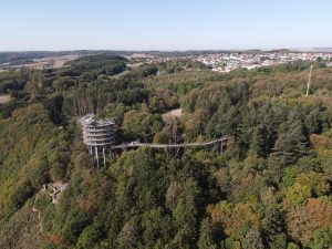
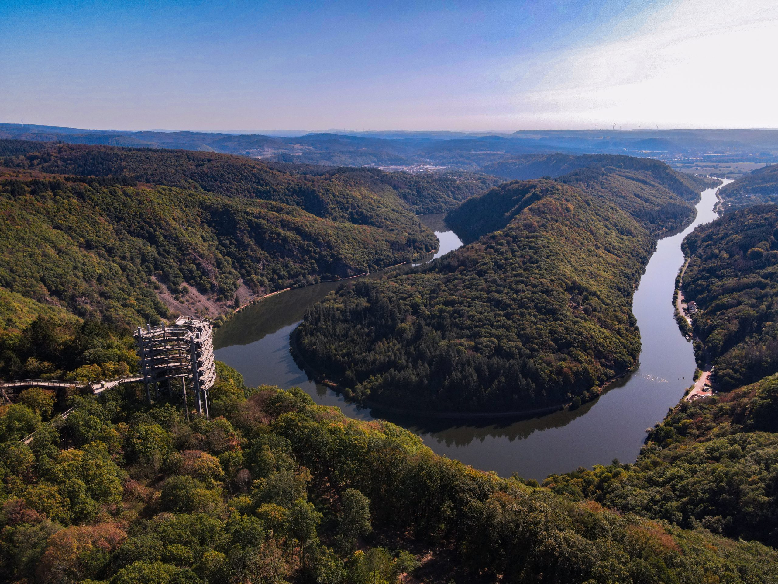
The great Saarschleife near Mettlach is a world-renowned landmark of the Saarland. The geotope is unique, not only because of the beautiful landscape, but also because of the complex geological processes that led to its formation beginning millions of years ago. The Saarschleife was the destination of a visit by Frederick William IV, King of Prussia, and Queen Elisabeth in the year 1856 (Daddder, 2020). They were fascinated by the spectacular landscape as seen from the observation deck “Cloef” that still exists today (Fig. 1). That word originates either from the Celtic term for “steep valley” or the name of the Clefmont dynasty, whose descendants ruled the region during medieval times. Their coat of arms represented keys, in French “clé”, from which the word „Cloef“ could be based (Dadder, 2020). Next to the “Cloef” observation deck, there is a viewing tower with a height of 42 m and a treetop path allowing for a majestic aerial view of the Saarschleife (see Fig. 3) (baumwipfelpfade.de).
How and when did the Saarschleife form?
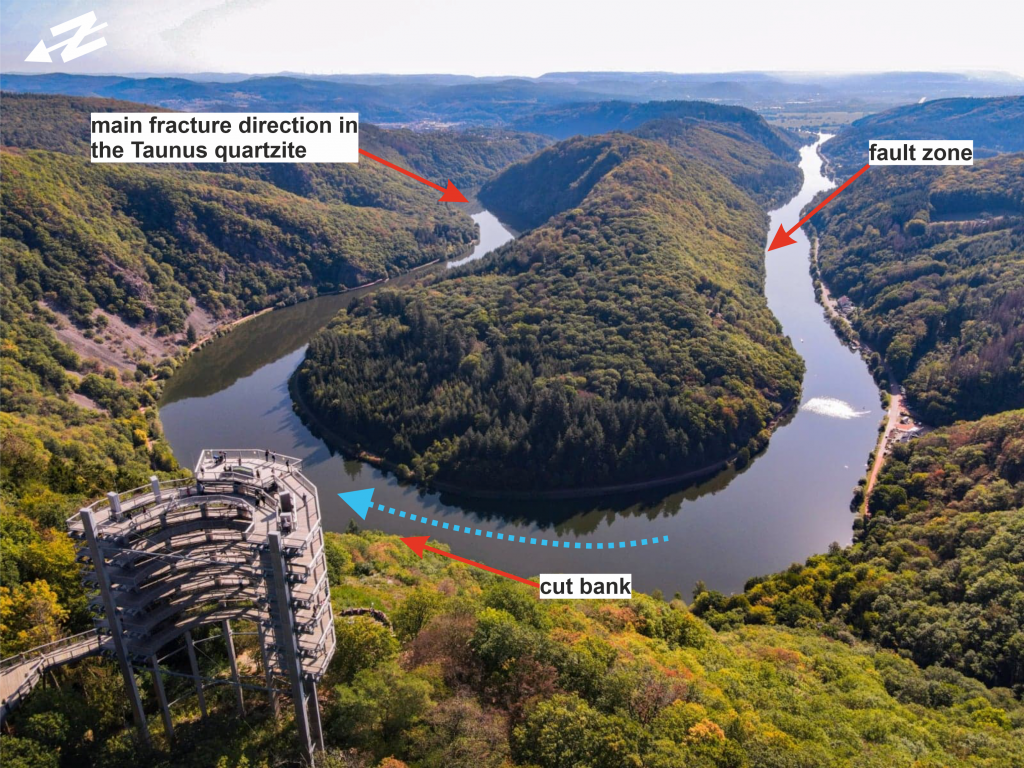
The bend in the river Saar near Mettlach resulted from the interaction of surface processes with the bedrock whereby the geomorphologically fascinating landform was caused by deep-seated geological structures. Even to experts, the meander appears paradoxical at first sight as it is cut into the hard Taunus quartzite rock.
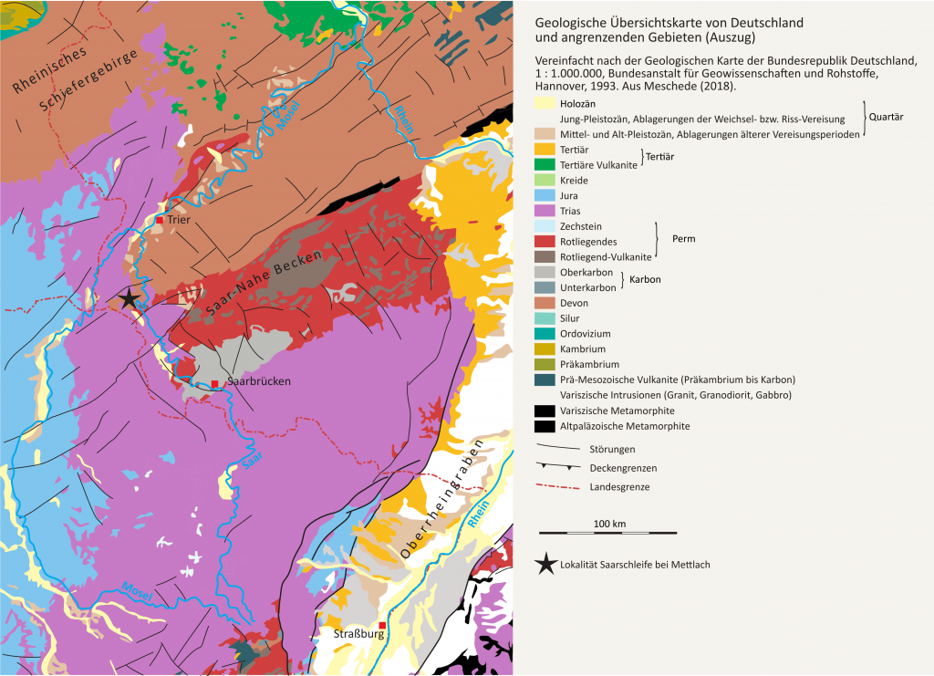
The Saarschleife is embedded in a densely forested landscape with the basement consisting of Lower Devonian Taunus quartzite rock, which is unconformably overlain by younger deposits (Schneider, 1991). The quartz-rich sediment that later became the Taunus quartzite were deposited about 410 million years ago (Early Devonian) in a tropical shallow sea prior to compaction and subsequent diagenesis (Kremb-Wagner et al., 2012). During the Carboniferous around 350 million years ago, tectonic processes in the course of the Variscan orogeny deformed the rock layers and formed a high mountain range. In the following geological eras, the Variscan mountain range was then eroded and levelled for the most part. Extensive triassic deposits of Buntsandstein and Muschelkalk sequences were then deposited unconformably above the Taunus quartzite in the S and SW (Fig. 2) (Schneider, 1991).
About 23 million years ago at the Oligocene-Miocene boundary, the river Saar was flowing across an almost planar land surface, known as a peneplain. At that time the river crossed Buntsandstein rocks about 300 m above the present-day surface in a NW direction (Schall, 1968; Schneider, 1991). Over the course of several million years the deepening of the river bed continued. During the Pleistocene, the river eroded into the older underlying hard Taunus quartzite, which was cemented and as a result more erosion-resistant (Schneider, 1991).
The deepening of the river was accompanied by tectonic movements. Due to the uplift of the southern margin of the Hunsrück and progressing fluvial erosion, the Saar river incised down into the Taunus quartzite. River valleys of such origin are called antecedent valleys or water gaps whereby the erosive power of the river was maintained at the same rate as the tectonic uplift.
The river Saar kept its flow direction but was significantly influenced by faults within the bedrock (Schneider, 1991). The direction of strike of one of the main faults influencing the flow of the river is NNE-SSW, which caused the flow to deviate from its S to N course several times (Becker, Kneuper & Schall, 1968). The southern section of the Saarschleife follows the before mentioned NNE-SSW trending fault lines, whereas the northern part was deflected by a NW-SE striking fault zone (Fig. 3).
Furthermore, an epigenetic formation of the meander is discussed among geologists and geomorphologists. According to the hypothesis, a river system was already established in the pre-Triassic relief at the Hunsrück margin, in which Upper Rotliegend and Middle Buntsandstein sediments were deposited (Schall, 1968; Becker, Kneuper & Schall, 1968). When the Saar reached these layers during erosion and deepening during the Pleistocene, the river shifted its bed towards more easily erodible sediments. In this way, an influence from the tectonic pattern present in the Devonian bedrock is assumed to help establish a pre-Triassic river network.
In summary, the Saarschleife can be seen as an antecedent river meander influenced both by tectonic structures and the erosive resistance of the bedrock.
The river Saar from its source to mouth – from a geoscientific viewpoint
The river Saar originates in NE France, about 50 km W of Strasbourg, and flows about 240 km before it feeds into the river Moselle in Konz in SW Germany (Rhineland-Palatinate).
According to geographical units, the Saar comprises three sections: the upper, middle and lower Saar valley (Harmand, 2007; Cordier et al., 2012). Near Mettlach, the Saar has already left the upper Saar valley with its Permian and Triassic sandstones and conglomerates of the Vosges and the Triassic limestones and marls of the eastern Paris basin (Fig. 3). In the middle Saar valley near Mettlach the river encounters Triassic Buntsandstein, magmatic rocks and the Taunus quartzite. In the lower Saar valley, the river crosses the Devonian strata of the Hunsrück (Fig. 3). When crossing the harder quartzite rocks of the Hunsrück, the Saar flows through impressive canyons before flowing into the Moselle, where the river bed widens due to less resistant rocks such as shales and sandstones (Cordier et al., 2012).
The regional corner
An excerpt of a poem about the river Saar by Christel Ehl
Die Saar
(von der Quelle bis zur Mündung)
…
„Der Waldgrat und die dunkle Burg,
gefällig von ihr umwunden
und hinter rosa – schimmernder Wand,
bei der nächsten Biegung entschwunden.
Wo sich der Reiher schwingt vom Nest,
wo sich erhebt die Cloef,
wo Vogelfelsen ragen weit,
hat sie ihr schönstes Relief.
Noch einmal wendet sie den Lauf
und schon im Weiterstreben,
erwachsen ihr hangab, hangauf,
jetzt traubenschwere Reben.“
…
(Ehl, 1998)
An excerpt from a poem by Christel Ehl was not only translated into the Mosel-Franconian dialect, but also recited by Marietta Schmitz (pictured).

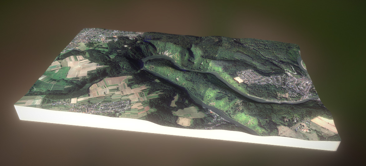
3D model
Impressions


References
Becker, H., Kneuper, G. & Schall, A. (1968): Zur Paläomorphologie im Jungvariszikum des Saarlandes. Geologische Rundschau, 58, 128–144, http://doi.org/10.1007/BF01820599.
baumwipfelpfade.de, see www.baumwipfelpfade.de/saarschleife, last accessed on 05.05.2021.
Cordier, S., Harmand, D., Lauer, T., Voinchet, P., Bahain, J.-J. & Frechen, M. (2012): Geo-chronological reconstruction of the Pleistocene evolution of the Sarre valley (France and Germany) using OSL and ESR dating techniques. Geomorphology, 165-166, 91–106, http://doi.org/10.1016/j.geomorph.2011.12.038.
Dodder, see www.saarland-lese.de/index.php?article_id=403, last accessed on 28.03.2021.
Ehl, C. (1998): Die Saar. In: Heimat- und Kulturverein Trier-Saarburg (eds.) Unweit der Saarschleife: Zeichnungen, Sagen und Gedichte aus der Saargegend. Alta Silva, Kell am See.
Harmand, D. (2007): Révision du système des terrasses alluviales de la Sarre entre Sarrebourg (France, Lorraine) et la confluence avec la Moselle à Konz (Allemagne, Rhénanie-Palatinat). Revue Géographique de l’Est, 47, http://doi.org/10.4000/rge.1536.
Kremb-Wagner, F, Koziol, M & Negendank, JFW (eds.) (2012): Trier und Umgebung: Geologie der Süd- und Westeifel, des Südwest-Hunsrück, der unteren Saar sowie der Maarvulkanismus und die junge Umwelt- und Klimageschichte; 13 Tabellen, 3., völlig neu bearbeitete Aufl. Borntraeger, Stuttgart.
Meschede, M. (2018): Geologie Deutschlands: Ein prozessorientierter Ansatz. Springer-Verlag.
Nichols, G. (2010): Sedimentology and stratigraphy, 2. ed., repr. Wiley-Blackwell, Chichester.
Schall, A. (1968): Grund- und Deckgebirge im Bereich der Mettlacher Saarschleife. Dissertati-on, Eberhard-Karls-Universität.
Schneider, H. (1991): Sammlung geologischer Führer: Saarland. Borntraeger, Berlin, Stuttgart.