TL;DR (too long; didn’t read)
The Lieth open pit in Schleswig-Holstein offers the opportunity to examine the interior of a salt dome. The dome consists of salt-bearing sedimentary rocks of the two Permian subunits, the Rotliegend and the Zechstein. The rocks ascended from a depth of at least six kilometres to the Earth’s surface. However, salty-tasting rocks are not encountered in the open pit, as the salt was dissolved by groundwater and transported away in solution. This process left behind an unconsolidated residue, the so-called “Liether limestone ash”, which, because of its use as fertiliser, was mined and thus generated the open pit.
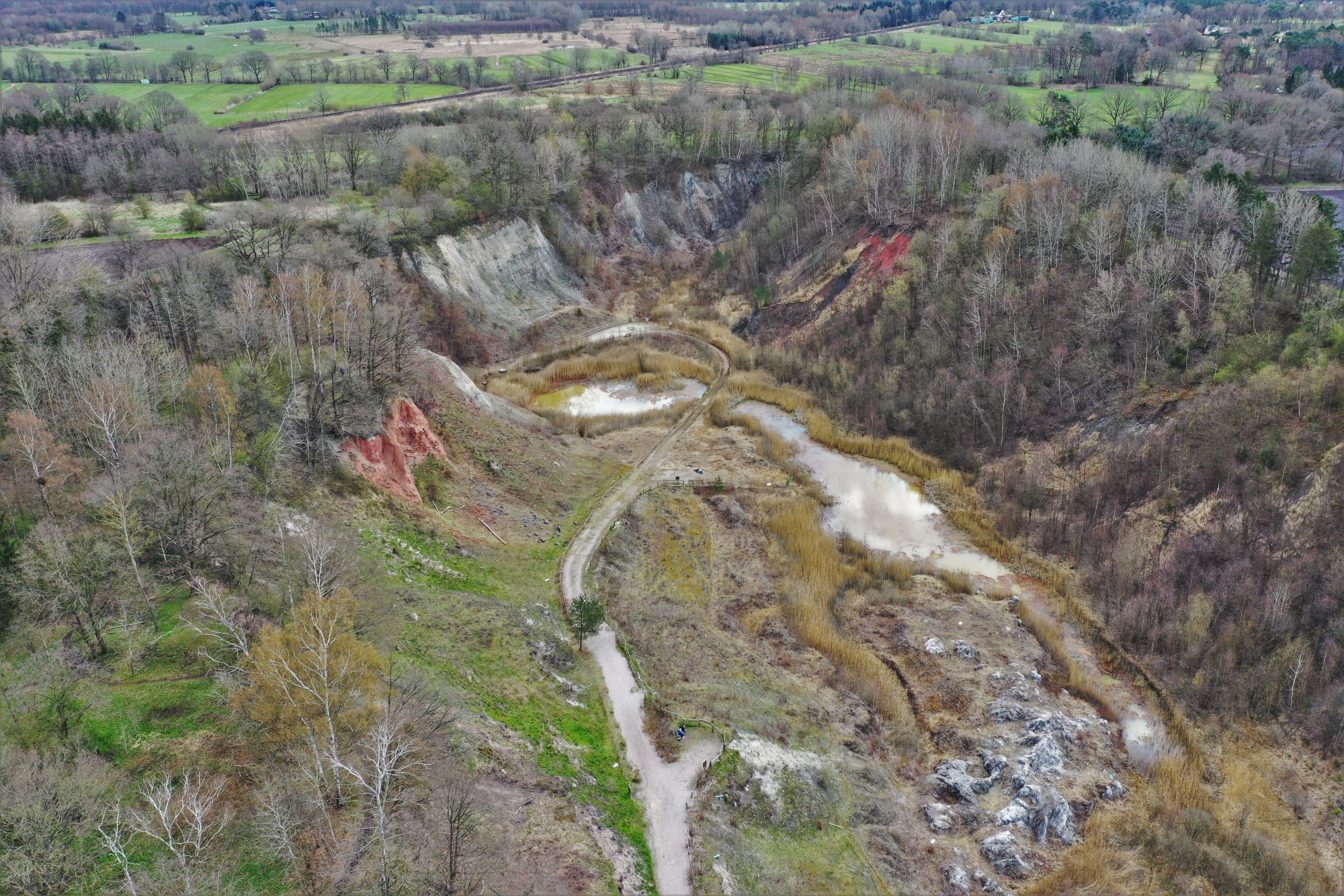
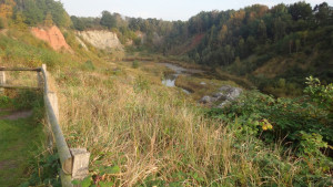
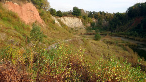
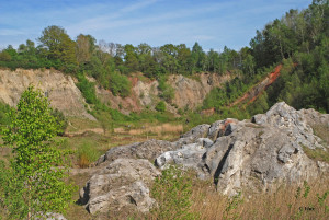
Where in Germany is it possible to stroll through the top portions of a salt dome, considering that rocks of such geological structures are buried commonly at a depth of several kilometers below the Earth’s surface? The Lieth open pit, located near Elmshorn in southwestern Schleswig-Holstein, offers visitors to experience the lithological and structural intricacies of the Elmshorn salt dome. The existence of the open pit stems from mining lime ash, used as fertilizer, from the end of the 19th century until 1991. In the same year, the open pit was established as a nature reserve, followed in 2006 by its listing as a national geotope. The Lieth open pit, the floor of which lies at a depth of 18 m below sea level and, therefore, requires permanent artificial drainage, is open to visitors all year round.
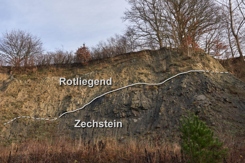
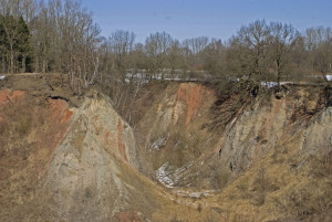
The open pit straddles the top of the Elmshorn salt dome structure, composed of Permian sedimentary rocks. Not only are these rocks the oldest ones exposed in Schleswig Holstein, they also host the boundary of the two subunits of Permian rocks, the Rotliegend and the Zechstein. At Rotliegend times, respective rocks were located at latitudes of today’s Sahara desert and formed in a shallow continental basin, bordered to the south by the Variscan mountain belt. Due to the rather large distance of transport from the mountains and the climatic desert conditions, the basin was filled with pelite and intercalated salt and gypsum layers (Ernst, 1931; Gagel, 1925; Prange ,1993).
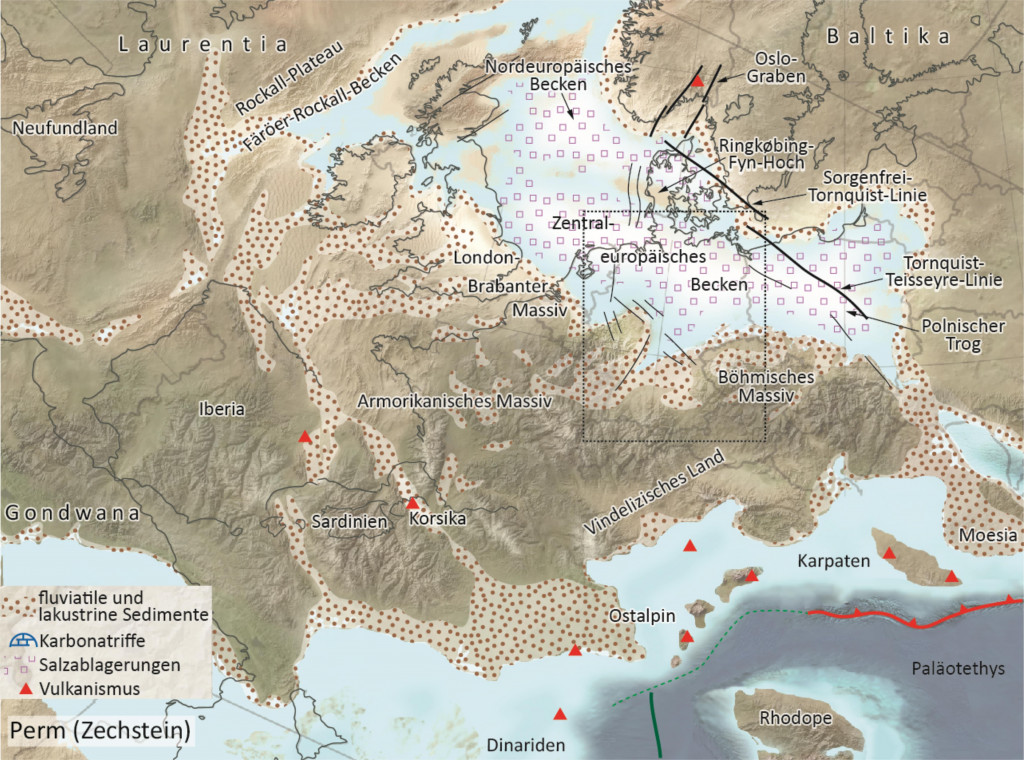
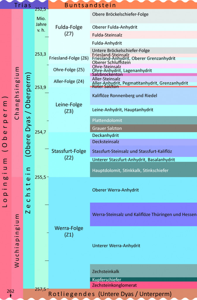
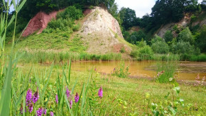
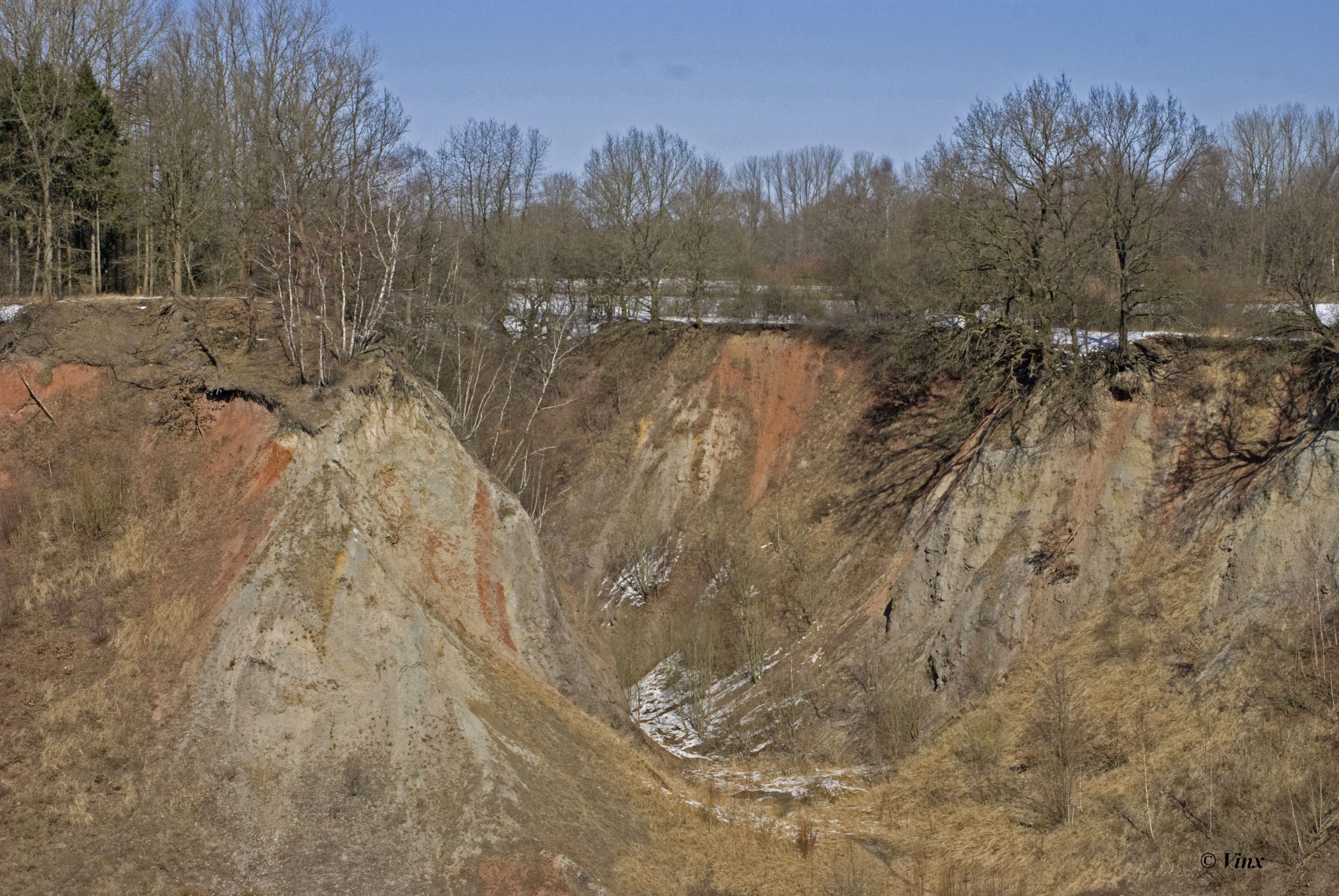
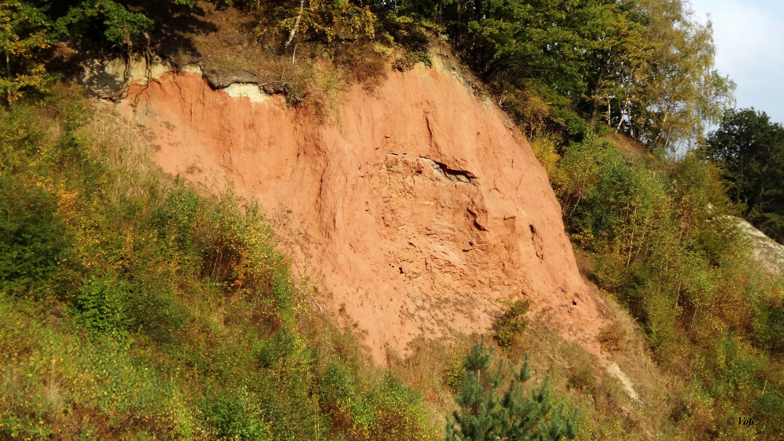
Following the Rotliegend, sea water flooded the shallow continental basin and formed the marginal Zechstein Sea, crudely occupying today’s area between the UK, Poland and Scandinavia (Fig. 1). Repeated flooding and drainage, including intermittent separation of the marginal sea from the ocean, and evaporation caused cyclic deposit formation (Fig. 2). Rocks of the Werra and Staßfurt cycles are exposed in the open pit. Following flooding, the Werra cycle started with the production of large quantities of organic material that accumulated at the sea floor. Here, anoxic conditions generated sapropel, which then transformed to copper slate. Next, limestone, formed from lime sludge, is exposed in the eastern wall of the open pit (Fig. 3). The Werra cycle ended with the deposition of evaporites, notably gypsum, spectacularly exposed in the center of the open pit. Stink slate, owing its name to the bituminous smell, in the open pit is attributed to the Staßfurt sedimentary cycle. Evaporite deposits exceeding 1000 m in thickness precipitated according to the respective water solubility of products, beginning with gypsum (CaSO4 × H2O), followed by rock salt (NaCl) and potassium and magnesium salts (Ernst, 1931; Lotze, 1936; Grube & Grube 2002).
Post-Permian sedimentary rocks in northern Germany reached a thickness of approximately 5000 m. The density of these rocks is higher than that of the underlying Permian salt rocks. This density difference and pressure at depth caused salt rocks to viscously flow toward, and into, tectonic fracture zones. Ever since 200 million years ago, this process continues. Ongoing lateral flow of salt rocks toward fracture zones caused the overlying sedimentary host rocks to subside (Vollmer, 1988; Prange, 1993; Grube, 1997).The entire North German geological realm is replete with cylindrical and planar salt diapirs. A unique characteristic of the Elmshorn salt dome is the so called double salinar structure (German: Doppelsalinar): While most of the salt domes in North Germany are made up merely of Zechstein salt, the Elmshorn features also Rotliegend salt rock (Prange, 1993; Grube, 1997; Grube & Grube 2002).
Ascending salt causes imbrication, folding and overturning of (host) rock layers during their transport. The eastern wall of the Lieth open pit impressively reveals overturned strata, evident by Rotliegend rocks overlying younger copper schist and Zechstein limestone (Fig. 3). Moreover, the salt-baring rocks nicely display the result of dissolution caused by groundwater, leaving behind insoluble rock, notably gypsum exposed in the center of the open pit. Staßfurt salt rocks affected by dissolution form the “Liether Kalkaschen”. Thus, visitors of the open pit will not encounter pristine Permian salt rocks, but its chemical residues and halotectonic structures instead (Grube, 1953; Vollmer, 1988).
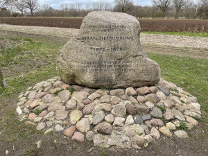
Another highlight of the Lieth open pit area is the nearby site of an exploration drill hole, active between 1872 and 1878, and operated for the purpose of finding coal seams. The drill hole reached a depth of 1,338 m below the surface, thus holding a world record in deep drilling at the time. Instead of coal seams, however, pristine rock salt was encountered at depths below 180 m. In recognition of the deep drilling world record, an engraved erratic bolder was placed near the north rim of the Lieth open pit (see model below) (Gagel, 1925; Lotze, 1936).
3D models
Impressions


References
Ernst, W. 1931: Über das Perm von Lieth bei Elmshorn (Holstein). Mitteilungen aus dem Mineralogisch-Geologischen Staatsinstitut in Hamburg 12, 49-124.
Grube, A. 1997: Geologie des Deckgebirges der Salzstruktur Elmshorn, Berichte – Reports, Geologisch-Paläontologisches Institut der Universität Kiel, Nr. 87.
Grube, A. & Grube, F. 2002: Zur Geologie der Liether Kalkgrube und des Salzstockes Elmshorn. Beiheft zum European Journal of Mineralogy 14, Nr. 1, 243-248.
Grube, E.-F. 1953: Tektonik und Oberflächenbild des Salzstockes Elmshorn. Diplomarbeit, Mathematisch-Naturwissenschaftliche Fakultät der Universität Hamburg.
Gagel, C. 1925: Über die stratigraphische Stellung und Beschaffenheit der roten Permschichten Norddeutschlands. Zeitschrift der Deutschen Geologischen Gesellschaft 77, 27-30.
Lotze, F. 1936: Das rote Salzgebirge von Lieth bei Elmshorn unterpermisch. Zentralblatt für Mineralogie, Geologie und Paläontologie, Abt. B, No. 5, 177-191.
Meschede, M. 2018: Geologie Deutschlands: Ein prozessorientierter Ansatz. 2. Auflage, Springer Spektrum, Berlin.
Prange, W. 1993: Das Perm von Lieth bei Elmshorn, 1843-1993. Die Heimat – Zeitschrift für Natur- und Landeskunde von Schleswig-Holstein und Hamburg 100, Nr. 9, 257-266.
Vollmer, T. 1988: Geologische Neuaufnahme der Liether Kalkgrube. – Unveröffentlichter DFG-Abschlussbericht Th 126/15-2, 49 S. und Anhang, Hamburg.