[north of the Harz mountains near Weddersleben; 51°45’26.5″N 11°05’03.2″E]
TL;DR (Too long; did’nt read)
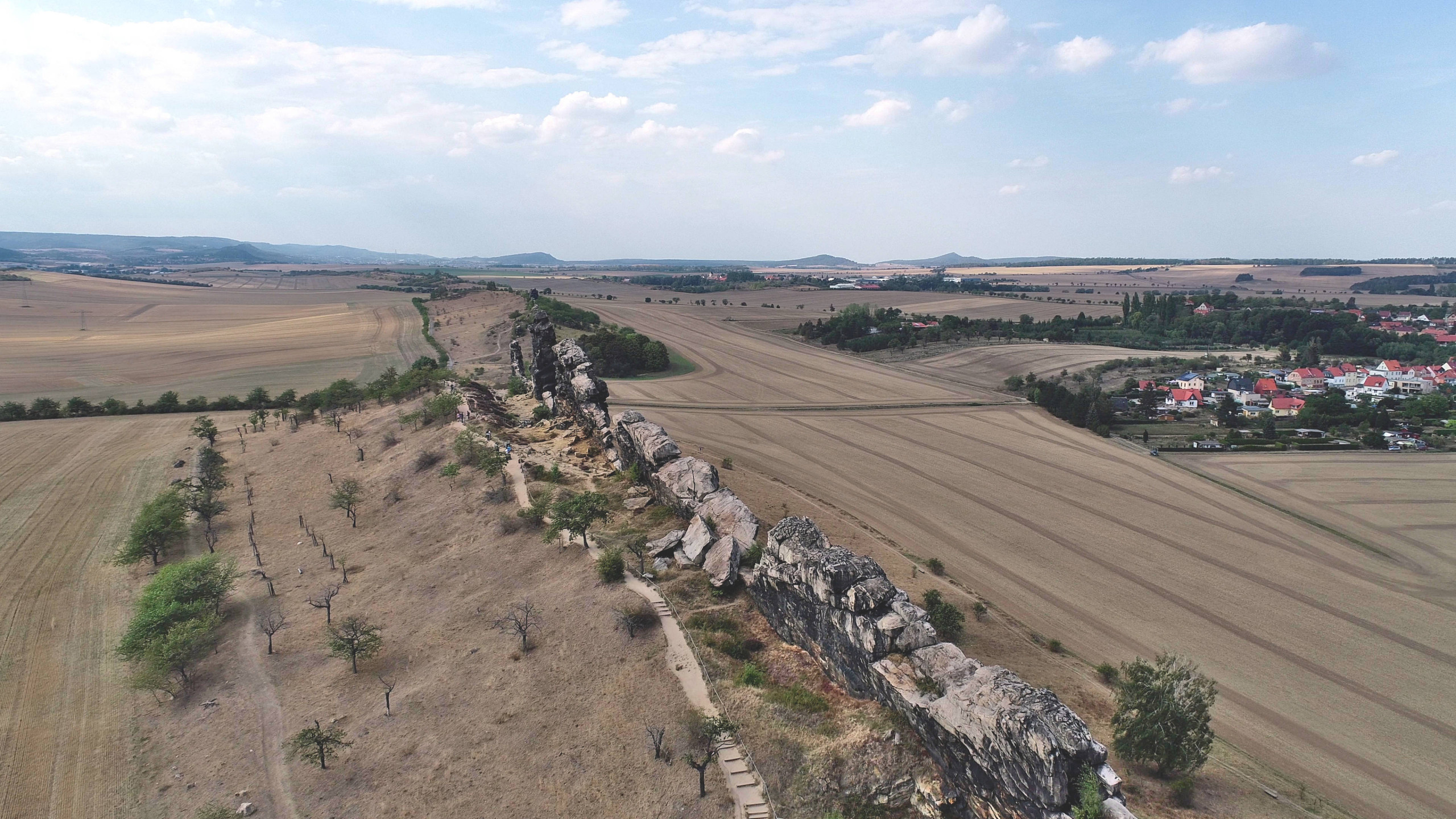
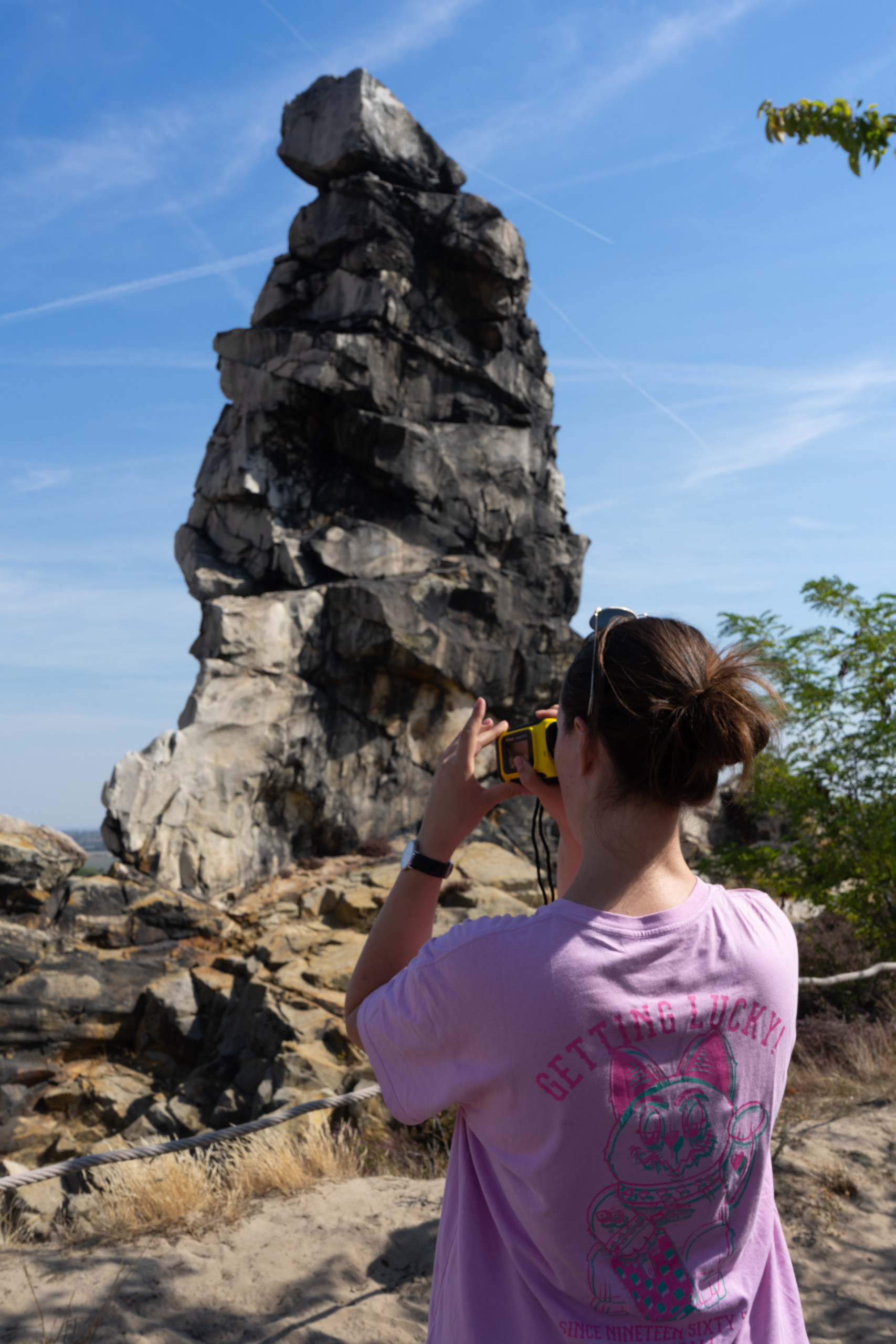
In the northern Harz foreland between Ballenstedt in the east and Blankenburg in the west, steep, sometimes meter-high sandstone cliffs form an imposing natural phenomenon over a length of approx. 20 km, which is known as the Teufelsmauer. The rugged, erosion-resistant cliffs are formed by layers of silicified sandstone, the formation of which is associated with the uplift of the Harz Mountains and their overthrust to the northern foreland during the Upper Cretaceous. The Königstein, Mittelstein and Papenstein sections south and south-west of Weddersleben have been under nature protection since 1935. In 2006, the Teufelsmauer was awarded national geotope status and is now an important geopoint in the UNESCO Geopark Harz – Braunschweiger Land – Ostfalen.
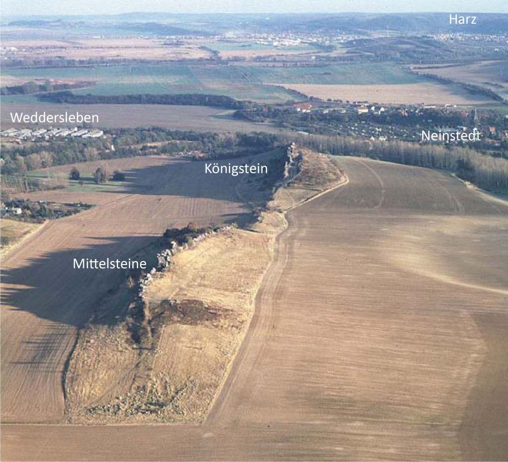
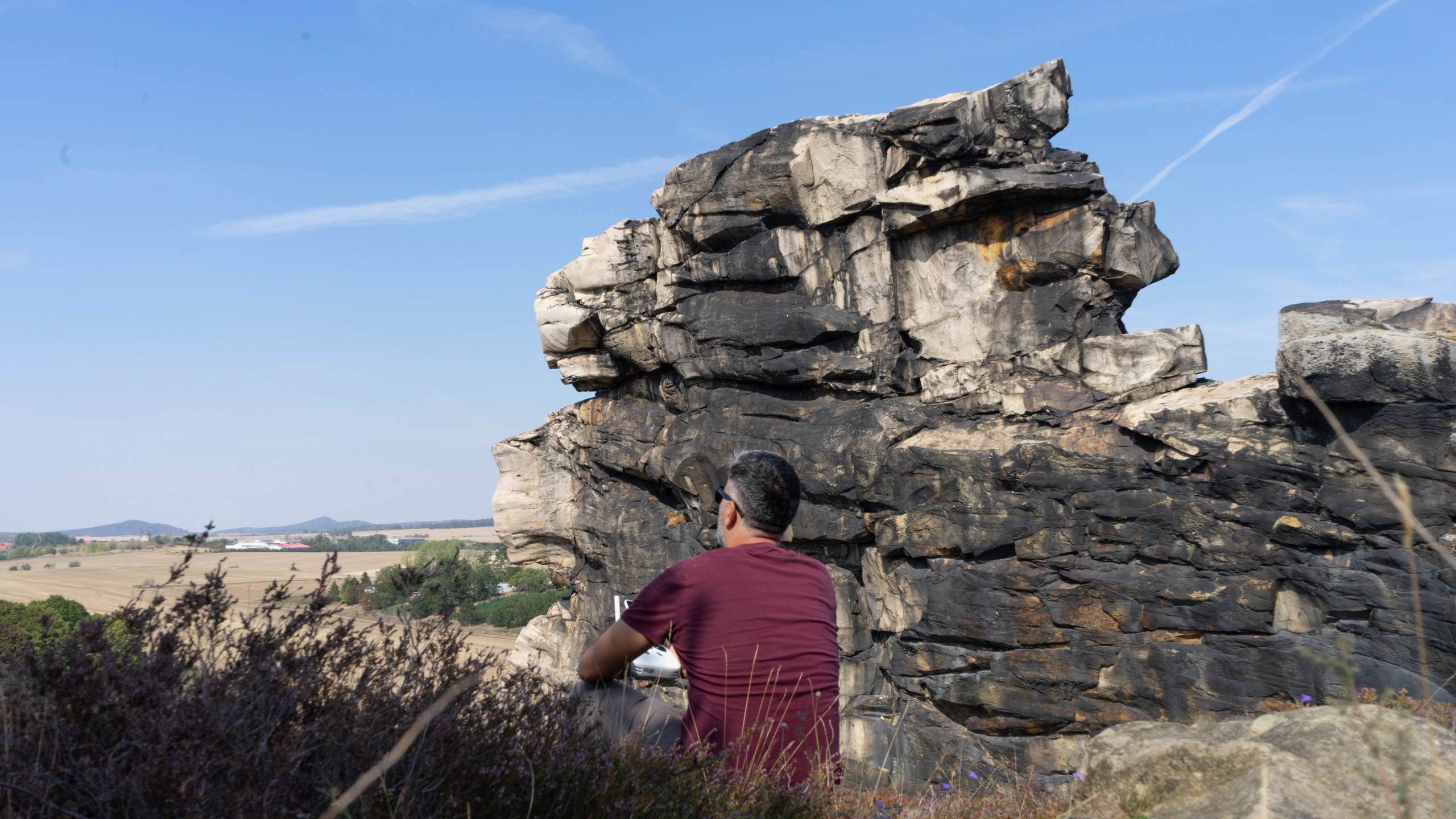
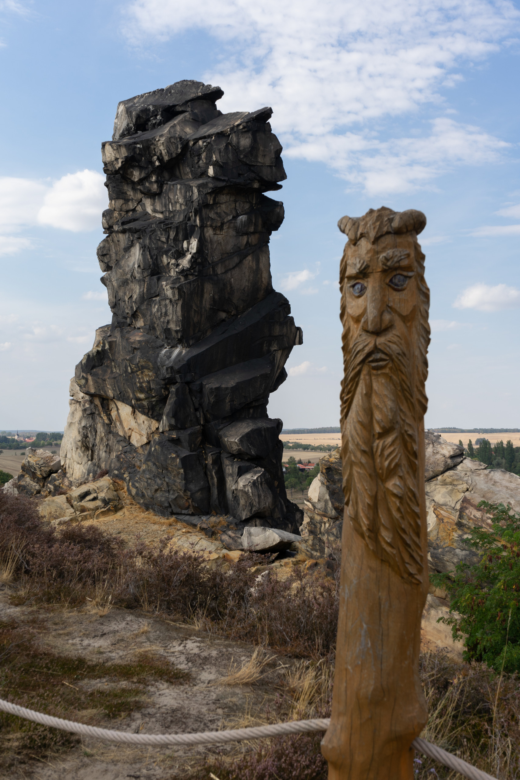
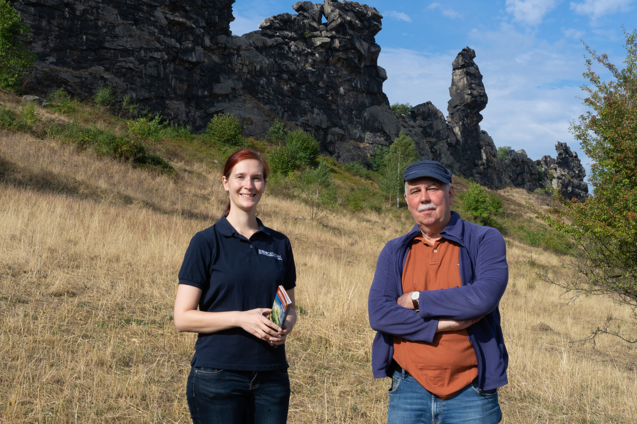
Sandstone cliffs of the Teufelsmauer tower over the landscape by several meters and usually form elongated crests of a few hundred meters in length. In detail, three areas should be mentioned that draw attention to themselves locally with their own names: The Gegensteine near Ballenstedt, the Königstein, Mittelsteine and Papensteine groups of three between Weddersleben and Neinstedt (Fig. 1) and in the west the jagged rock formations of Hamburger Wappen, Gewittergrotte and Großvaterfelsen between the villages of Blankenburg and Timmenrode. Numerous myths and folk tales indicate the significance of the Teufelsmauer rock fromation, which is well-known in the Harz foothills.
Just as natural rocks from the surrounding area were used in many villages to construct houses and buildings, the sandstone blocks of the Teufelsmauer were also used with pleasure. In Weddersleben, for example, the church was rebuilt in 1714 using stones from the Teufelsmauer. In order to prevent further quarrying of the coveted building material at the Teufelsmauer, the Royal Prussian District Administrator Friedrich Ludwig Weyhe issued a ban on quarrying stones and sand at the Teufelsmauer as early as 1833. Another important protection came in 1935 when the responsible government in Magdeburg declared the rock formation and the surrounding farmland a nature reserve. Of the more than 8,000 nature reserves today in Germany, the area near Weddersleben is one of the oldest nature reserves in Germany. The Teufelsmauer is prominently represented in the coat of arms of the village of Weddersleben. In addition to the government offices and the Geopark (link to: https://www.harzregion.de/de/geopark.html), the Friends of Teufelsmauer Weddersleben e.V. (link to: http://www.teufelsmauerverein.de /) to care for and preserve the natural phenomenon. The association has also created a garden on the southern side of the Königstein with native plants of the northern Harz flora.
Geological outline
The Teufelsmauer with its steep layers (Fig. 2 left) consists of fine to medium-grained, rarely coarse-grained sandstones of white, light to dark gray colour. Stratigraphically, these hard sandstones near Weddersleben can be assigned to the Heidelberg Formation, a lithological unit of the Santonium stage in the Upper Cretaceous. Older rocks of the Involutus sandstone from the Coniacian stage can also be found in other parts of the Teufelsmauer. The predominantly calcareous and clay-dominated deposits of the Upper Cretaceous are interspersed with sandstone and limestone. Due to intensive cementation of the sand grains, the hard sandstones in the area of the Teufelsmauer form erosion-resistant rocks, while the softer rocks in the area are more easily eroded. Thus, the sandstone cliffs mostly occur in the center of the elevations and contribute to the mound formation by their resistance to erosion (Fig. 1).
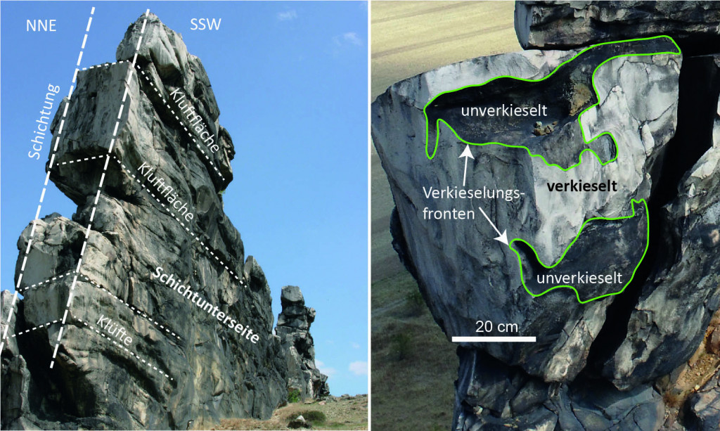
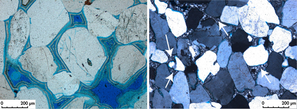
Due to the layer-bound silicification of the sandstones, the cliff-like protrusion of the rocks as erosion residues is widespread along the wall. The siliceous cementation varies in intensity and special forms of erosion occur in less silicified sections. There, the sand grains are often removed and the more silicified sections become visible through bulging concave or convex boundaries (Fig. 2 right). The bulging small forms of the erosion walls trace the silicification fronts in the rock (Fig. 2 right). The silicification by rising silicate-rich fluids led to the cementing of the sand grains, with different cements being formed (Fig. 3) and the pore space between the sand grains being partly completely filled with quartz cement.
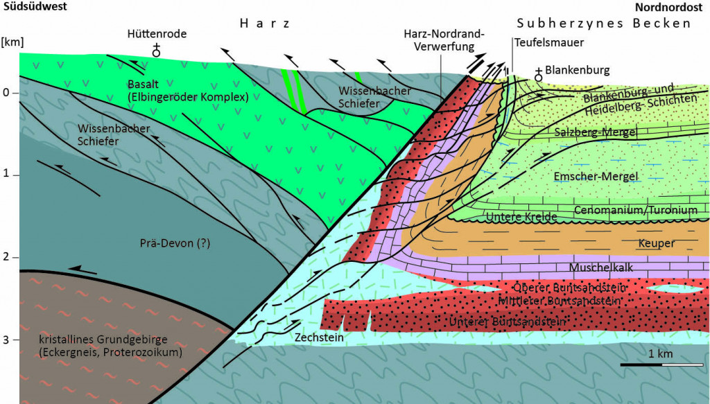
The silicification of the Teufelsmauer is concentrated on a very narrow (maximum 10 m wide) area, whereby the line-like spread on the surface over 20 km approximately parallel to the northern edge of the Harz Mountains is due to tectonic causes in the underground. The Harz northern margin overthrust and the bending of the younger strata at the southern margin of the Sub-Hercynian Basin (Fig. 4) play the central role. Other faults were created in connection with the thrust zone and the overturn, creating additional pathways for the ascent of fluids. Higher pressure solution on siliceous rocks possibly led to increased silicon concentrations in the rising fluids in the bend area, which led to silicification in the steep sandstone layers of the Upper Cretaceous.
Geological development at the northern edge of the Harz Mountains
Today’s secondary mountain range of the Harz Mountains is made up of Palaeozoic rocks that were folded around 300 million years ago as part of mountain formation. Along its northern edge fault, the Harz has been lifted out by up to 7 km as a half-horst in the last 88 million years (since the Upper Cretaceous). In the course of plate tectonic movements in the Mediterranean area, especially in connection with the folding of the Pyrenees, there was a narrowing of the crust in Central Europe, as a result of which the Harz block was pushed north-east onto its foreland.
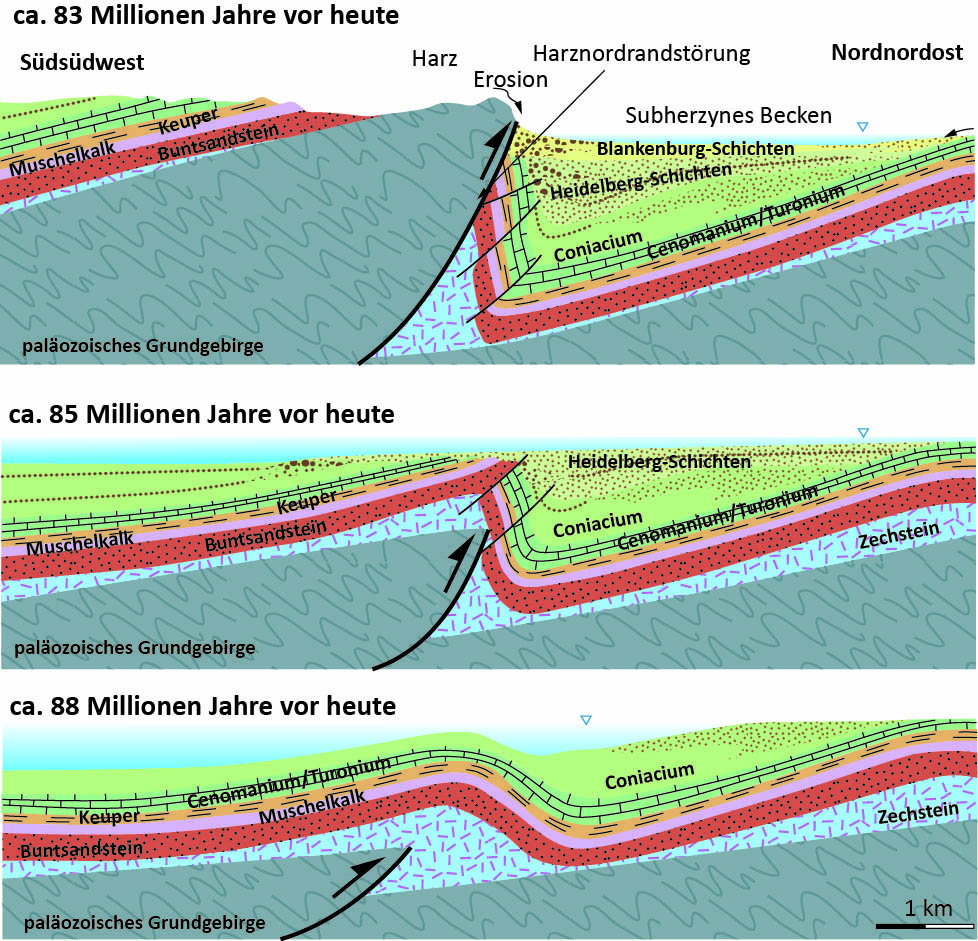
In just a few million years the Harz uplifted, causing flexure-like bending of the younger strata along the northern Harz rim fault (Fig. 5). During this uplift, the young, overlying sediments were removed in the Harz region, while in the Harz foreland, subsidence of the underground in the Upper Cretaceous (Santonian and Campanian) resulted in thicker deposits of the Heidelberg and Blankenburg formations (Fig. 5). A bending of the layers from Buntsandstein to the Upper Cretaceous deposits led to a steep position in the uplift zone. The silciification caused the monadnock zones of the Teufelsmauer against weathering. Processes associated with the glaciation during the Elster and Saale glacial periods influenced the geomorphology. At that time, glaciers from the north reached as far as the northern edge of the Harz Mountains. The melt water washed away the rocks that had become loose due to weathering and exposed the monadnock parts of the Teufelsmauer.
The Legends of the Devil’s Wall
Natural rock formations are often central figures of legends and myths (see also the legend of the devil’s table (link to https://digitalgeology.de/der-teufelstisch). The Harz Mountains, as a mysterious low mountain range, are generally rich in legends and myths, and that’s how it is It is not surprising that stories about the Devil’s Wall are very well known. The legends and myths are entwined around attempts to explain the imposing natural rocks, with the devil, as God’s adversary, very often becoming the protagonist. Several variations on the explanation of the conspicuous rocks of the Teufelsmauer are widespread, where a short version of a legend variant of the “devil and the rooster” is given here:
“Aeons ago, when God and the devil divided the earth between themselves, it was agreed between the two that the devil should have all the land that he could wall around in one night before cockcrow. On that night, when the devil began his building work, there was an old woman who wanted to sell a rooster in the market. She stumbled in the dark and the rooster was startled and began to crow. The devil heard this and thought that his time was up and in his rage he tore down the devil’s wall again. The remains have survived to this day.”
3D models
Impressions


Bibliography
Fischer, C., Waldmann, S., und von Eynatten, H., (2013): Spatial variation in quartz cement type and concentration: an example from the Heidelberg formation (Teufelsmauer outcrops), Upper Cretacous Subhercynian Basin, Germany, https://doi.org/10.1016/j.sedgeo.2013.03.009
Funkel, C., Schönbrodt, R. et al. (2002) 150 Jahre Schutz der Teufelsmauer Tagung und Festveranstaltung am 08.06.2002 in Weddersleben. Berichte des Landesamtes für Umweltschutz Sachsen-Anhalt. – Halle (2002) SH 1, 83 Seiten, ISSN 1619-4071
Günther, E. & Bürger, G. (2015): Die Teufelsmauer am Harz, Edition Leipzig, Leipzig, ISBN 978-3-361-00712-3.
Meschede, M. (2018): Geologie Deutschlands. Ein prozessorientierter Ansatz, Springer, 2. Auflage, Doi 10.1007/978-3-662-45298-1
Voigt, T., Wiese, F., von Eynatten, H., Franzke, H.-J. & Gaupp, R. (2006): Facies evolution of syntectonic Upper Cretaceous deposits in the Subhercynian Cretaceous Basin and adjoining areas (Germany). – Z. dt. Ges. Geowiss., 157: 203–244, Stuttgart, Doi: 10.1127/1860-1804/2006/0157-0203