TL;DR (too long; didn’t read)
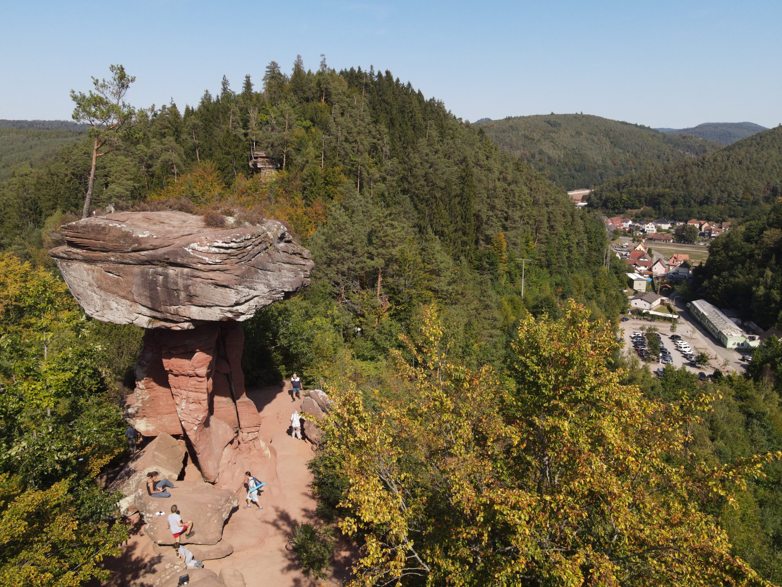
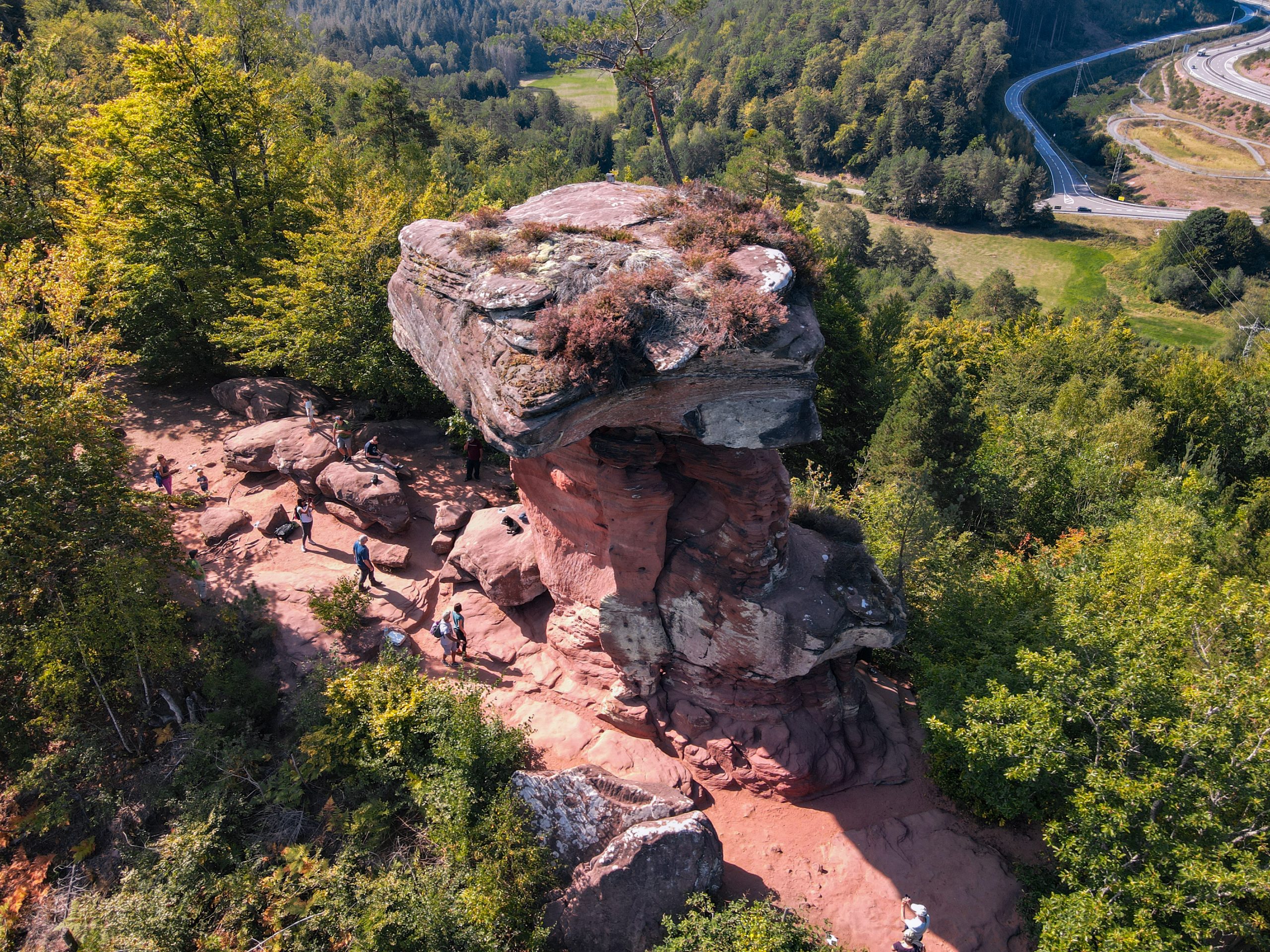
The Devil’s Table is made of sandstone. The devil is said to have set up the table, but of course that is not true. In fact, the rock of the Devil’s Table formed 250 million years ago in a desert. And the shape was created by wind and rain working the rock. In the process, soft rock layers weathered more easily than hard, solid rock layers. That’s why a kind of table with a large tabletop was formed from the more massive, resistant sandstone layers. There are still many such rocks in the Palatinate Forest. A visit is worthwhile.
Unususal geologic formations have fascinated humans since prehistoric times. Especially in their most bizarre forms where such landforms are considered to result from the work of the devil. This applies to the Devil’s Table in the Hauenstein Holiday Region in the Rhineland-Palatinate (near Hinterweidenthal), which, according to legend represents the devil’s dining table. The poem by Johann Martin Jäger alias “Fritz Claus” (1853 –1923) narrates the story. The certain passage explaining the formation of the table might be translated as follows:
At the speed of lightning
the companion frightening
takes two fresh rocks well stable
and puts them up as table.
Upon the devil’s dinner stay
into the night he went away
the table where he sat,
he left just where it’s at.
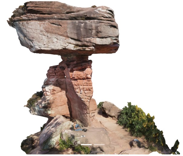
In reality, the mushroom-shaped rock with a height of 14 m is a typical landform of the regions Hauenstein and the Dahner Felsenland (Dahn Rockland) and its formation can solely be ascribed to natural processes.
Overview
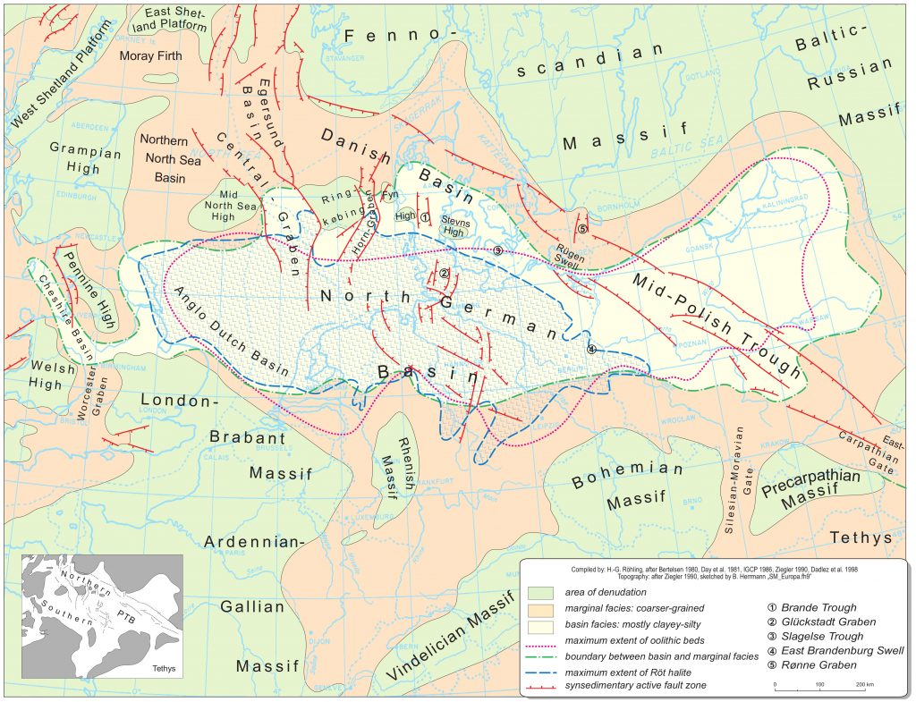
During the Early Triassic or Buntsandstein Epoch (between 252.5 and 246 Ma ago), the supercontinent Pangea started to break up. Today’s central European region was located around 40 degrees north of the equator and far away from any ocean shoreline. At that time, the area was covered by a large terrestrial intracratonic sedimentary basin that occupied the interior of the continent. This Central European Basin or Germanic Basin was characterised by an arid and warm desert-like climate with minimal precipitation (Lepper et al. 2013, Paul & Puff 2013, Meschede & Warr 2019).
The sediments deposited during this period were mostly of terrestrial origin. The sedimentary environment was characterised by long-distance transports with braided river systems transporting material from surrounding elevated areas into the basin (Fig. 1). The rivers ended in depressions without outlets, that dominated vast areas of the Germanic Basin. Apart from fluvial sedimentation wind-blown aeolian sediment accumulated in the basin during dry periods (DSK 2013).
Around 200 Ma later during the Paleogene Period, around 48 Ma before present, the area of the Upper Rhine Graben was regionally tilted. The tectonic processes also affected the proximal Palatinate Forest Region, which led to breaking up into blocks that experienced rapid uplift and rotation. Subsequent erosive processes removed young rocks and exposed the underlying Buntsandstein successions.
It was not until the Late Cenozoic Era (5 – 0,01 Ma ago) that the Palatinate Forest gained today’s appearance under the influence of the glacial and interglacial periods. A complex relief was formed of exposed Buntsandstein rock with deep valleys and diverse mountain shapes. Especially the Dahner and Annweilerer Felsenland (Dahn and Annweiler Rockland) in the southern Palatinate Forest are characterised by varied and bizarre rock landscapes (Lang et al. 2007). These characteristic strata of the Buntsandstein show overhangs, rock gates and notable mushroom- and tablet-shaped pillars formed by the differentially eroded alternating successions of hard and soft rock. The Devil’s Table reflects the effect of such small-scale weathering processes in a spectacular way (Lang et al. 2007, LBG-RLP 2005).
Stratigraphy
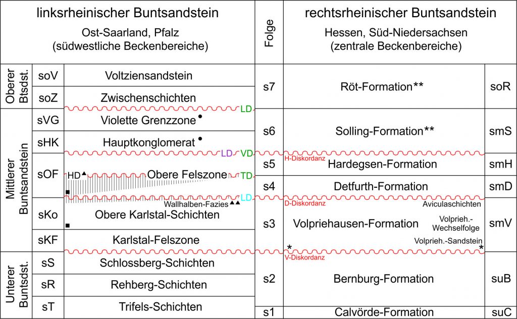
The German term Buntsandstein is used to describe a lithostratigraphic rock unit that consists largely of interbedded sand-, silt- and claystones. These lithologies were sedimented in a large basin covering an area equivalent to that lying between England and Poland in a west-east direction and Scandinavia and Switzerland in the north-south direction (DSK 2013). The Hauenstein region and the Dahner Felsenland (Dahn Rockland) are dominated by sandstones that were deposited during the Early Buntsandstein, about 252.2 until 249 Ma before present. This succession – that also forms the Devil’s Table – is locally known as the Rehberg Formation, which is stratigraphically equivalent to the Bernburg Formation of the Central Germanic Basin (Fig. 2) (Lang et al. 2007, Röhling et al. 2018).
Lithologic description
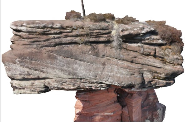
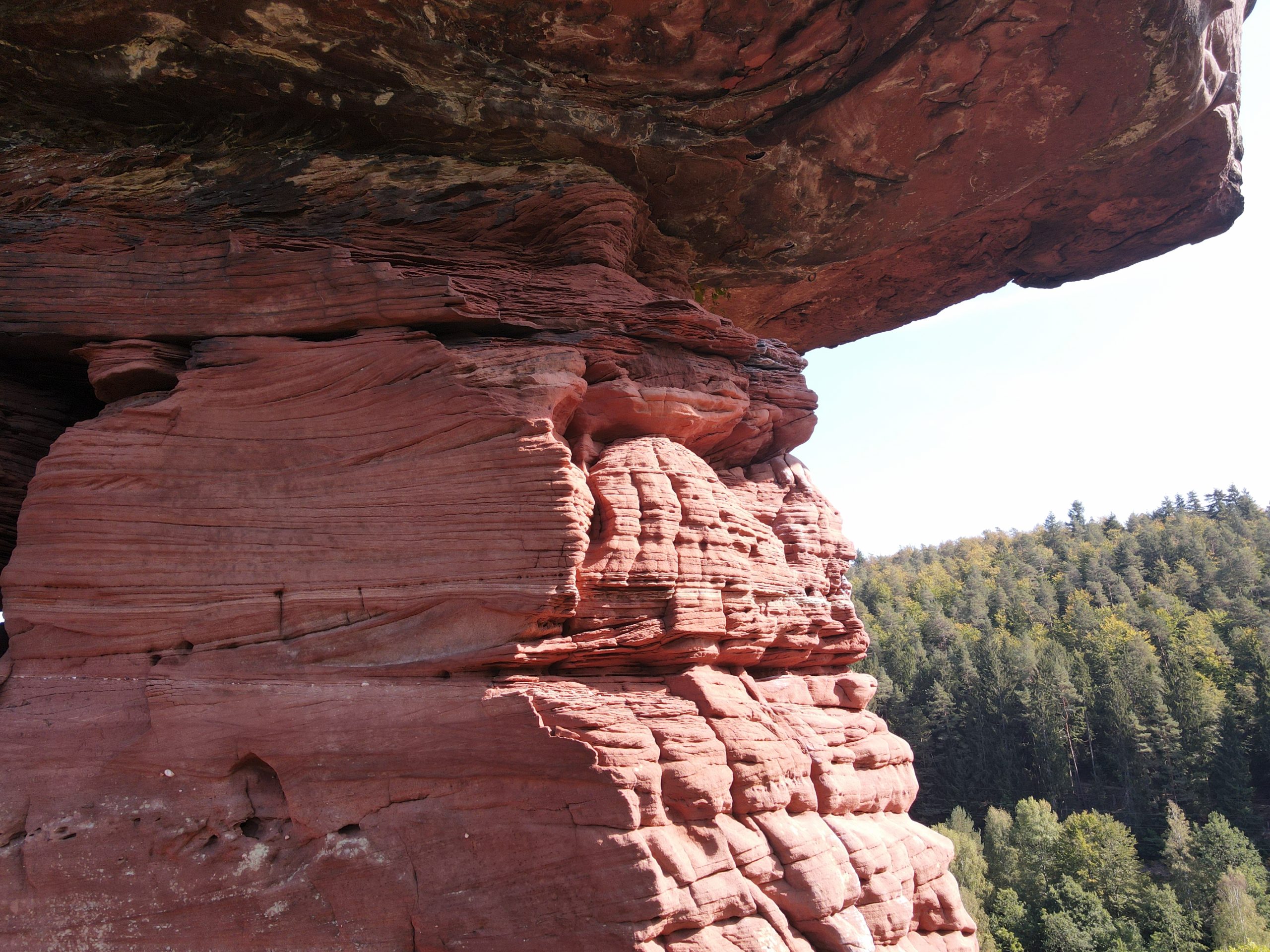
The circa 150 m thick Rehberg Formation is characterised by alternating hard sandstones – so called “rock zones” and less resistant sandstones referred to as “thin layers“ (Lang et al. 2007).
The rock zones consist of partially silicified, medium- and coarse-grained sandstones, which are in part gravelly. These are commonly massive cross-bedded units with a red to violet colouration, which were deposited mostly in a fluvial environment. The fine-grained “thin layers“ on the other hand show no silicification and indicate a deposition in stagnant water. These layers were deposited mostly as eolian sediment (Lang et al. 2007, Dachroth 2013). The lack of boulders and clay in these fine-grained and light brick-red to orange coloured thin layers indicates the absence of water for the most part of the sedimentation process. They represent wind-driven sedimentary deposits in closed drainage basins under arid and hot desert climate conditions (LBG-RLP 2010). The provenance area of the sediment was the Gallic land, which bordered the Buntsandstein basin to the west. This uplifted source area stretched from today’s Belgium to the Massif Central in France (Lang et al. 2007, Lepper et al. 2013, Dittrich 2013).
Formation of the Devil’s Table
The Rehberg Formation commonly forms table rock formations such as the Devil’s Table. The siliceous harder rock zones lie on top of the softer thin layers, that are more susceptible to weathering and erosion. The tabletop-like blocks protect the remaining pillars of less resistant material from further erosion. The shape of the Devil’s Table and its thin pillars is defined by preexisting fractures at the upper and lower end of the tabletop (Lang et al. 2007).
The natural monument of the „Devil’s Table“ represents an important landmark of the Palatinate Forest and was classified as a „National Geotope“ in 2006 (Lang et al. 2007). In the surrounding are, there are numerous impressive rock formations in the Hauenstein region and the Dahn Rockland, which are also worth a visit!
3D model

A high-resolution, scientifically usable model is available at V³Geo.
Impressions


Dialect corner
Many legends have grown up around the Devil’s Table. We don’t want to keep them from you. And what could be better than telling these stories in Palatinate dialect? For this we were able to win over a real Palatine native speaker. He recently won a prize in the Dannstadter Höhe 2020 dialect competition. In the audio, Hermann Josef Settelmeyer (pictured) recites two tales about the Devil’s Table.

References
Dachroth, W.R. (2013): Der Buntsandstein der Lothringen-Pfalz-Senke. – In: Deutsche Stratigraphische Kommission (Eds.; Koordination und Redaktion: J. Lepper & H.-G. Röhling für die Subkommission Perm-Trias): Stratigraphie von Deutschland XI. Buntsandstein. – Schriftenr. dt. Ges. Geowiss., 69: 487–513.
Dittrich, D. (2013): Wüsten und Meere – Die Pfalz im Erdmittelalter.– In: Haneke, J. & Kremb, K. (Hrsg.): Beiträge zur Geologie der Pfalz. Veröffentlichungen der Pfälzischen Gesellschaft zur Förderung der Wissenschaften, 110: 20-34.
DSK (Deutsche Stratigraphische Kommission, Eds.; Koordination und Redaktion: J. Lepper & H.-G. Röhling für die Subkommission Perm-Trias) (2013): Stratigraphie von Deutschland XI. Buntsandstein. – Schriftenr. Dt. Ges. Geowiss., 69: 657 S.; Stuttgart (E. Schweizerbart’sche Verlagsbuchhandlung).
Lang, R., Frost, F. & Dittrich, D. (2007): Ein grandioses Naturdenkmal – Der „Teufelstisch“ bei Hinterweidenthal im Pfälzer Wald. – In: Look, E.-R. & Quade, H. (Hrsg.): Faszination Geologie. Die bedeutendsten Geotope in Deutschland, 2. Aufl.: 106–107.
Landesamt für Geologie und Bergbau Rheinland-Pfalz (LBG-RLP) (Ed.) (2010): Steinland-Pfalz. Geologie und Erdgeschichte von Rheinland-Pfalz. – 84. S.; Stuttgart (E. Schweizerbart’sche Verlagsbuchhandlung).
Lepper, J., Rambow, D. & Röhling, H.-G. (2013): Lithostratigraphie des Buntsandstein in Deutschland. – In: Deutsche Stratigraphische Kommission (Eds.; Koordination und Redaktion: J. Lepper & H.-G. Röhling für die Subkommission Perm-Trias): Stratigraphie von Deutschland XI. Buntsandstein. – Schriftenr. dt. Ges. Geowiss., 69: 69–149.
Meschede, M. & Warr, L. N. (2019): The Geology of Germany. A process-oriented approach. – 305 pp.; (Springer).
Paul. J & Puff, P. (2013): Das Klima des Buntsandstein. – In: Deutsche Stratigraphische Kommission (Eds.; Koordination und Redaktion: J. Lepper & H.-G. Röhling für die Subkommission Perm-Trias): Stratigraphie von Deutschland XI. Buntsandstein. – Schriftenr. dt. Ges. Geowiss., 69: 213–221.
Röhling, H.-G., Lepper, J., Diehl, M., Dittrich, D., Freudenberger, W., Friedlein, V., Hug-Diegel, N. & Nitsch, E. (2018): Der Buntsandstein in der Stratigraphischen Tabelle von Deutschland 2016 / The Buntsandstein Group in the Stratigraphic Table of Germany 2016. – Z. Dt. Ges. Geowiss. (German Journal of Geology), 169 (2): 151–180.
Text: Rosalie Kunkel, Proofs: Martin Meschede/Greifswald, Heinz-Gerd Röhling/Berlin, Valeska Decker/Bonn, Gösta Hoffmann/Bonn.
Translation: Laurence N. Warr/Greifswald.